

Doi Pui To Ban Pong
A cycling route starting in Chiang Mai, Chiang Mai, Thailand.
Overview
About this route
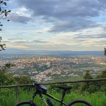
This is a fairly long cross country ride on the less travelled southern side of the Doi Suthep/Pui national park. It begins at Bhubing helipad on Sriwichai Rd., continues through Ban Hmong Doi Pui to the Doi Pha Klong viewpoint and then turns south running through forest, fields, orchards and bamboo groves until it reaches Samoeng Rd. (1269). It continues with an optional loop through the Krisdadoi hills before it returns to Samoeng Rd. From Ban Pong it takes a shortcut through the foothills directly to Ban Huai Sai and then the canal road.
The ride is 80% offroad over forest path, single track trails, fire roads and farm roads. The terrain is partly rough and requires a mountain bike. The total ascent is almost 700m and the total descent is 1700m.- -:--
- Duration
- 41.1 km
- Distance
- 576 m
- Ascent
- 1,659 m
- Descent
- ---
- Avg. speed
- ---
- Max. altitude

Route quality
Waytypes & surfaces along the route
Waytypes
Track
18.2 km
(44 %)
Quiet road
11.1 km
(27 %)
Surfaces
Paved
14.1 km
(34 %)
Unpaved
26.2 km
(64 %)
Unpaved (undefined)
21.7 km
(53 %)
Asphalt
8.8 km
(21 %)
Continue with Bikemap
Use, edit, or download this cycling route
You would like to ride Doi Pui To Ban Pong or customize it for your own trip? Here is what you can do with this Bikemap route:
Free features
- Save this route as favorite or in collections
- Copy & plan your own version of this route
- Sync your route with Garmin or Wahoo
Premium features
Free trial for 3 days, or one-time payment. More about Bikemap Premium.
- Navigate this route on iOS & Android
- Export a GPX / KML file of this route
- Create your custom printout (try it for free)
- Download this route for offline navigation
Discover more Premium features.
Get Bikemap PremiumFrom our community
Other popular routes starting in Chiang Mai
 Chiang Mai - Rim Ping
- Distance
- 65 km
- Ascent
- 30 m
- Descent
- 29 m
- Location
- Chiang Mai, Chiang Mai, Thailand
 Chiangmai U to Doi Su Thep view point
- Distance
- 18.1 km
- Ascent
- 404 m
- Descent
- 403 m
- Location
- Chiang Mai, Chiang Mai, Thailand
 Chiang Mai
- Distance
- 669.4 km
- Ascent
- 1,461 m
- Descent
- 1,461 m
- Location
- Chiang Mai, Chiang Mai, Thailand
 DoiSuthep
- Distance
- 49.9 km
- Ascent
- 1,107 m
- Descent
- 1,109 m
- Location
- Chiang Mai, Chiang Mai, Thailand
 Cycle in Thai 03 : Chiang Rai, Myanmar
- Distance
- 263.6 km
- Ascent
- 781 m
- Descent
- 703 m
- Location
- Chiang Mai, Chiang Mai, Thailand
 MHS Loop
- Distance
- 533.7 km
- Ascent
- 5,294 m
- Descent
- 5,289 m
- Location
- Chiang Mai, Chiang Mai, Thailand
 Reverse Samoeng Loop back via Bhubbing Palace
- Distance
- 116.8 km
- Ascent
- 2,847 m
- Descent
- 2,847 m
- Location
- Chiang Mai, Chiang Mai, Thailand
 CPB small circle
- Distance
- 13.7 km
- Ascent
- 73 m
- Descent
- 71 m
- Location
- Chiang Mai, Chiang Mai, Thailand
Open it in the app