

Sa Coma- auf die Serra de Llevant-Sa Coma "Traumtour am Meer"
A cycling route starting in Son Servera, Balearic Islands, Spain.
Overview
About this route
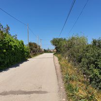
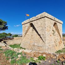
The route starts in Sa Coma on the east coast and initially heads south along the coastal road. The first major town is Portocristo, known for the famous Dragon Caves, which were once used as underground refuges. A detour via Cala d'Or and Porto Pedro is always worthwhile – with magnificent views of the rocky coastline. It is also worth taking a detour to Cala Figuera. The village has retained much of its original character. The second half of the route returns mainly via flat and quiet secondary roads. But wait, a few more elevation meters need to be climbed on the 510 m high Puig de San Salvador – the Mountain of Tears.
- -:--
- Duration
- 119.5 km
- Distance
- 751 m
- Ascent
- 750 m
- Descent
- ---
- Avg. speed
- ---
- Max. altitude

Continue with Bikemap
Use, edit, or download this cycling route
You would like to ride Sa Coma- auf die Serra de Llevant-Sa Coma "Traumtour am Meer" or customize it for your own trip? Here is what you can do with this Bikemap route:
Free features
- Save this route as favorite or in collections
- Copy & plan your own version of this route
- Split it into stages to create a multi-day tour
- Sync your route with Garmin or Wahoo
Premium features
Free trial for 3 days, or one-time payment. More about Bikemap Premium.
- Navigate this route on iOS & Android
- Export a GPX / KML file of this route
- Create your custom printout (try it for free)
- Download this route for offline navigation
Discover more Premium features.
Get Bikemap PremiumFrom our community
Other popular routes starting in Son Servera
 Sa Coma-Felanitx-San Salvador-Manacor-cala-Rajada
- Distance
- 76.8 km
- Ascent
- 934 m
- Descent
- 879 m
- Location
- Son Servera, Balearic Islands, Spain
 Cala Bona, Son Servera, Santa Margalida, Petra, Manacor, Son Carrió
- Distance
- 79 km
- Ascent
- 689 m
- Descent
- 692 m
- Location
- Son Servera, Balearic Islands, Spain
 Mallorca: Cala Millor-Cala Morlanda-Son Carrió-Sant Llorenç des Cardassar-volta a Calicant-Son Carrió-Son Servera-Cala Bona-Cala Millor
- Distance
- 56.9 km
- Ascent
- 532 m
- Descent
- 534 m
- Location
- Son Servera, Balearic Islands, Spain
 Lange Ausfahrt vom 22.04.16, 15:25
- Distance
- 45.6 km
- Ascent
- 286 m
- Descent
- 278 m
- Location
- Son Servera, Balearic Islands, Spain
 Parc de la Mar S/N, Cala Millor to Carrer Cristòfol Colom s/n, Cala Millor
- Distance
- 33.9 km
- Ascent
- 228 m
- Descent
- 217 m
- Location
- Son Servera, Balearic Islands, Spain
 Malle 2018 340 km
- Distance
- 352.2 km
- Ascent
- 979 m
- Descent
- 970 m
- Location
- Son Servera, Balearic Islands, Spain
 día 1 Brother
- Distance
- 23 km
- Ascent
- 937 m
- Descent
- 932 m
- Location
- Son Servera, Balearic Islands, Spain
 Mallorca a peu: punta de n'Amer des de Cala Millor
- Distance
- 8.1 km
- Ascent
- 61 m
- Descent
- 60 m
- Location
- Son Servera, Balearic Islands, Spain
Open it in the app