

Giro de Rafenstein
A cycling route starting in San Paolo, Trentino-Alto Adige, Italy.
Overview
About this route
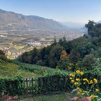
Tour to the legendary Rafensteiner Bergstrasse at Jenesien. Averaging about 25 percent - maximum 40 percent gradient !!!!!!!!!!!!!!!!!!!!!!!!!!!!
- -:--
- Duration
- 27.4 km
- Distance
- 795 m
- Ascent
- 796 m
- Descent
- ---
- Avg. speed
- ---
- Max. altitude

Continue with Bikemap
Use, edit, or download this cycling route
You would like to ride Giro de Rafenstein or customize it for your own trip? Here is what you can do with this Bikemap route:
Free features
- Save this route as favorite or in collections
- Copy & plan your own version of this route
- Sync your route with Garmin or Wahoo
Premium features
Free trial for 3 days, or one-time payment. More about Bikemap Premium.
- Navigate this route on iOS & Android
- Export a GPX / KML file of this route
- Create your custom printout (try it for free)
- Download this route for offline navigation
Discover more Premium features.
Get Bikemap PremiumFrom our community
Other popular routes starting in San Paolo
 Missianer Weg nach Missianer Weg
- Distance
- 76.3 km
- Ascent
- 810 m
- Descent
- 867 m
- Location
- San Paolo, Trentino-Alto Adige, Italy
 St. Paul - Mendelpass - St. Paul
- Distance
- 32.3 km
- Ascent
- 1,212 m
- Descent
- 1,212 m
- Location
- San Paolo, Trentino-Alto Adige, Italy
 2010.07.26 St.Pauls - Mendelpass - Kaltern
- Distance
- 46.1 km
- Ascent
- 1,218 m
- Descent
- 1,218 m
- Location
- San Paolo, Trentino-Alto Adige, Italy
 eppan - bozen
- Distance
- 26.6 km
- Ascent
- 725 m
- Descent
- 727 m
- Location
- San Paolo, Trentino-Alto Adige, Italy
 Mendelpass - Gampelpass
- Distance
- 70 km
- Ascent
- 1,679 m
- Descent
- 1,679 m
- Location
- San Paolo, Trentino-Alto Adige, Italy
 Weinrute
- Distance
- 20.3 km
- Ascent
- 349 m
- Descent
- 345 m
- Location
- San Paolo, Trentino-Alto Adige, Italy
 Montiggler Waldrunde
- Distance
- 20.6 km
- Ascent
- 367 m
- Descent
- 368 m
- Location
- San Paolo, Trentino-Alto Adige, Italy
 Waldschenke in Altenburg
- Distance
- 14.8 km
- Ascent
- 419 m
- Descent
- 53 m
- Location
- San Paolo, Trentino-Alto Adige, Italy
Open it in the app