

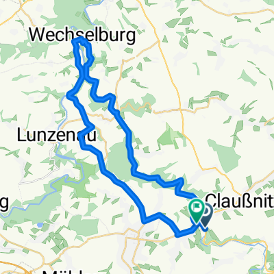
Chemnitztal Schlammschlacht
A cycling route starting in Taura, Saxony, Germany.
Overview
About this route
muddy lap with a fast return via the road
- -:--
- Duration
- 23.7 km
- Distance
- 272 m
- Ascent
- 272 m
- Descent
- ---
- Avg. speed
- ---
- Max. altitude
Route quality
Waytypes & surfaces along the route
Waytypes
Track
9.9 km
(42 %)
Quiet road
2.6 km
(11 %)
Surfaces
Paved
10.9 km
(46 %)
Unpaved
8.1 km
(34 %)
Asphalt
10.9 km
(46 %)
Ground
4 km
(17 %)
Continue with Bikemap
Use, edit, or download this cycling route
You would like to ride Chemnitztal Schlammschlacht or customize it for your own trip? Here is what you can do with this Bikemap route:
Free features
- Save this route as favorite or in collections
- Copy & plan your own version of this route
- Sync your route with Garmin or Wahoo
Premium features
Free trial for 3 days, or one-time payment. More about Bikemap Premium.
- Navigate this route on iOS & Android
- Export a GPX / KML file of this route
- Create your custom printout (try it for free)
- Download this route for offline navigation
Discover more Premium features.
Get Bikemap PremiumFrom our community
Other popular routes starting in Taura
 Chemnitztal Schlammschlacht
- Distance
- 23.7 km
- Ascent
- 272 m
- Descent
- 272 m
- Location
- Taura, Saxony, Germany
 UnteresChemnitztal-real
- Distance
- 29.3 km
- Ascent
- 303 m
- Descent
- 302 m
- Location
- Taura, Saxony, Germany
 20' - FTP-Test (Chemnitztal)
- Distance
- 11.4 km
- Ascent
- 174 m
- Descent
- 79 m
- Location
- Taura, Saxony, Germany
 schöne Runde
- Distance
- 83.2 km
- Ascent
- 660 m
- Descent
- 657 m
- Location
- Taura, Saxony, Germany
 Sa6_2Diethensd-Göritzhain-Lunzenau-(Rochsbg)-Amerika-Höllbach-Burgst-Cl
- Distance
- 31.6 km
- Ascent
- 375 m
- Descent
- 329 m
- Location
- Taura, Saxony, Germany
 Unteres Chemnitztal
- Distance
- 36.1 km
- Ascent
- 288 m
- Descent
- 290 m
- Location
- Taura, Saxony, Germany
 Mulderadweg
- Distance
- 221.4 km
- Ascent
- 210 m
- Descent
- 435 m
- Location
- Taura, Saxony, Germany
 Chemnitztalroute
- Distance
- 4.8 km
- Ascent
- 133 m
- Descent
- 134 m
- Location
- Taura, Saxony, Germany
Open it in the app