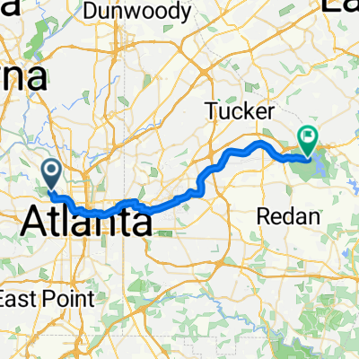
Stone Mountain Trail bike ride
A cycling route starting in Atlanta, Georgia, United States.
Overview
About this route
bike trail
- -:--
- Duration
- 26.5 km
- Distance
- 167 m
- Ascent
- 164 m
- Descent
- ---
- Avg. speed
- ---
- Max. altitude
Route quality
Waytypes & surfaces along the route
Waytypes
Cycleway
18.3 km
(69 %)
Quiet road
4.1 km
(15 %)
Surfaces
Paved
20.7 km
(78 %)
Concrete
14.2 km
(53 %)
Paved (undefined)
3.6 km
(14 %)
Continue with Bikemap
Use, edit, or download this cycling route
You would like to ride Stone Mountain Trail bike ride or customize it for your own trip? Here is what you can do with this Bikemap route:
Free features
- Save this route as favorite or in collections
- Copy & plan your own version of this route
- Sync your route with Garmin or Wahoo
Premium features
Free trial for 3 days, or one-time payment. More about Bikemap Premium.
- Navigate this route on iOS & Android
- Export a GPX / KML file of this route
- Create your custom printout (try it for free)
- Download this route for offline navigation
Discover more Premium features.
Get Bikemap PremiumFrom our community
Other popular routes starting in Atlanta
- bike tour through Atlanta
- Distance
- 13.4 km
- Ascent
- 180 m
- Descent
- 211 m
- Location
- Atlanta, Georgia, United States
- Ms. Senior's Sunday Ride
- Distance
- 15.2 km
- Ascent
- 202 m
- Descent
- 202 m
- Location
- Atlanta, Georgia, United States
- Westside Beltline to Stone Mountain
- Distance
- 38.7 km
- Ascent
- 221 m
- Descent
- 259 m
- Location
- Atlanta, Georgia, United States
- Stone Mountain Trail bike ride
- Distance
- 26.5 km
- Ascent
- 167 m
- Descent
- 164 m
- Location
- Atlanta, Georgia, United States
- Beltline Fall 23
- Distance
- 46.2 km
- Ascent
- 0 m
- Descent
- 0 m
- Location
- Atlanta, Georgia, United States
- Rico B-Day Ride 2010
- Distance
- 74.4 km
- Ascent
- 262 m
- Descent
- 265 m
- Location
- Atlanta, Georgia, United States
- Zarah Tavarez
- Distance
- 18.1 km
- Ascent
- 140 m
- Descent
- 187 m
- Location
- Atlanta, Georgia, United States
- Garibaldi Street Southwest 722, Atlanta to Garibaldi Street Southwest 724, Atlanta
- Distance
- 20.4 km
- Ascent
- 147 m
- Descent
- 147 m
- Location
- Atlanta, Georgia, United States
Open it in the app