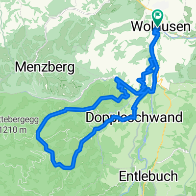
Wolhusen1
- 61.5 km
- 1,275 m
- 1,149 m
- Wolhusen, Canton of Lucerne, Switzerland
A cycling route starting in Wolhusen, Canton of Lucerne, Switzerland.
Overview
Route to the Napf.
Organizer Stöckli invites to the ride. Once a year a huge event with about 1400 bikers. We want to start early in the field, at 7:20 a.m. we set off through the Äbnetwald forest towards Twerenegg where at the right junction Oberlehn we make the first stop at Gmeinalp. Excellent provision as always to enjoy. I look for my bike among many and we set off again with the goal Ober Änzi which must be hard-earned at the end.
Downhill you can really let loose and enjoy until we get to the Wolf. Then the fun stops, the climb to Menzberg is extremely steep at the end. After Guezli and Banana we still have the last section to Wolhusen ahead. Wonderful meadow and field paths have to be mastered. Arrived at Zeil there is Bolognese and a beer.
Many thanks to all, especially the signposting teams.
Ride time 3:23:55
Distance 45.39 km
Average 13.35 km/h
Fastest 57.76 km/h
Ascent 1305 meters
Descent 1297 meters
Bike Specialized Stumpjumper Expert 2010
GPS Cyclemeter
Notes
created this 12 years ago
Route quality
Track
19.1 km
(42 %)
Quiet road
10.9 km
(24 %)
Paved
10.4 km
(23 %)
Unpaved
13.6 km
(30 %)
Gravel
9.5 km
(21 %)
Asphalt
7.3 km
(16 %)
Continue with Bikemap
You would like to ride Napf Marathon via Wolhusen Oberänzi or customize it for your own trip? Here is what you can do with this Bikemap route:
Free trial for 3 days, or one-time payment. More about Bikemap Premium.
Discover more Premium features.
Get Bikemap PremiumFrom our community
Open it in the app