

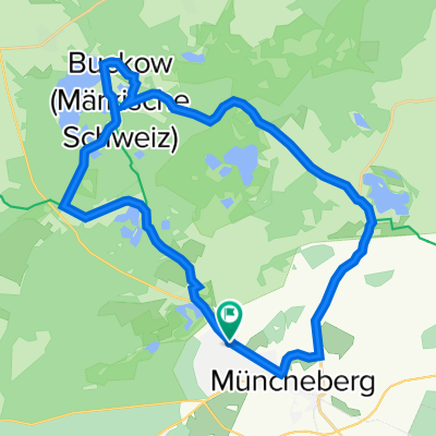
03.10.2013 Märkische Schweiz
A cycling route starting in Müncheberg, Brandenburg, Germany.
Overview
About this route
The eastern part is mostly characterized by country roads, otherwise lots of forest
- -:--
- Duration
- 44.5 km
- Distance
- 190 m
- Ascent
- 188 m
- Descent
- ---
- Avg. speed
- ---
- Max. altitude
Continue with Bikemap
Use, edit, or download this cycling route
You would like to ride 03.10.2013 Märkische Schweiz or customize it for your own trip? Here is what you can do with this Bikemap route:
Free features
- Save this route as favorite or in collections
- Copy & plan your own version of this route
- Sync your route with Garmin or Wahoo
Premium features
Free trial for 3 days, or one-time payment. More about Bikemap Premium.
- Navigate this route on iOS & Android
- Export a GPX / KML file of this route
- Create your custom printout (try it for free)
- Download this route for offline navigation
Discover more Premium features.
Get Bikemap PremiumFrom our community
Other popular routes starting in Müncheberg
 Kleine Buchholzrunde
- Distance
- 29.2 km
- Ascent
- 95 m
- Descent
- 94 m
- Location
- Müncheberg, Brandenburg, Germany
 Wanderung Märkische Schweiz
- Distance
- 16.9 km
- Ascent
- 188 m
- Descent
- 214 m
- Location
- Müncheberg, Brandenburg, Germany
 Müncheberg - Lübbenau/Spreewald
- Distance
- 90.9 km
- Ascent
- 408 m
- Descent
- 415 m
- Location
- Müncheberg, Brandenburg, Germany
 Oderbruchbahn-Radweg
- Distance
- 41.7 km
- Ascent
- 155 m
- Descent
- 158 m
- Location
- Müncheberg, Brandenburg, Germany
 Große Buchholzrunde
- Distance
- 37.8 km
- Ascent
- 157 m
- Descent
- 159 m
- Location
- Müncheberg, Brandenburg, Germany
 Große Westrunde
- Distance
- 51.1 km
- Ascent
- 289 m
- Descent
- 287 m
- Location
- Müncheberg, Brandenburg, Germany
 Märkische Schweiz
- Distance
- 78.7 km
- Ascent
- 305 m
- Descent
- 303 m
- Location
- Müncheberg, Brandenburg, Germany
 Eberswalder Straße 83, Müncheberg nach Eberswalder Straße 85, Müncheberg
- Distance
- 27.4 km
- Ascent
- 229 m
- Descent
- 230 m
- Location
- Müncheberg, Brandenburg, Germany
Open it in the app