

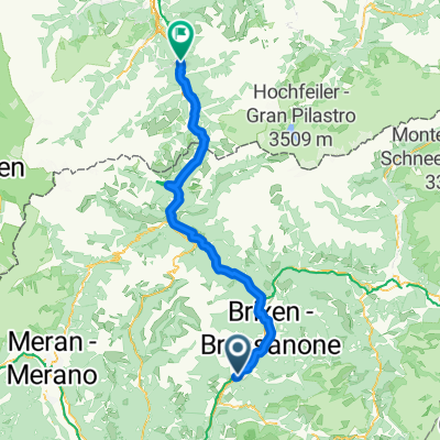
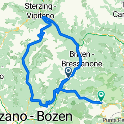
Giro Sarentino
A cycling route starting in Klausen, Trentino-Alto Adige, Italy.
Overview
About this route
Chiusa - Renon - Sarentino - Penness Pass - Vipiteno
- -:--
- Duration
- 133.2 km
- Distance
- 2,317 m
- Ascent
- 2,319 m
- Descent
- ---
- Avg. speed
- ---
- Max. altitude

Route quality
Waytypes & surfaces along the route
Waytypes
Road
14.6 km
(11 %)
Quiet road
9.3 km
(7 %)
Surfaces
Paved
109.2 km
(82 %)
Unpaved
1.3 km
(1 %)
Asphalt
109.2 km
(82 %)
Ground
1.3 km
(1 %)
Undefined
22.6 km
(17 %)
Continue with Bikemap
Use, edit, or download this cycling route
You would like to ride Giro Sarentino or customize it for your own trip? Here is what you can do with this Bikemap route:
Free features
- Save this route as favorite or in collections
- Copy & plan your own version of this route
- Split it into stages to create a multi-day tour
- Sync your route with Garmin or Wahoo
Premium features
Free trial for 3 days, or one-time payment. More about Bikemap Premium.
- Navigate this route on iOS & Android
- Export a GPX / KML file of this route
- Create your custom printout (try it for free)
- Download this route for offline navigation
Discover more Premium features.
Get Bikemap PremiumFrom our community
Other popular routes starting in Klausen
 Dolomitenrunde No2 2011
- Distance
- 139.3 km
- Ascent
- 3,314 m
- Descent
- 3,307 m
- Location
- Klausen, Trentino-Alto Adige, Italy
 Klausen Brixen Matrei
- Distance
- 81.4 km
- Ascent
- 2,037 m
- Descent
- 1,596 m
- Location
- Klausen, Trentino-Alto Adige, Italy
 Röckhof-Villanders-Barbian-Sauders
- Distance
- 15.1 km
- Ascent
- 767 m
- Descent
- 739 m
- Location
- Klausen, Trentino-Alto Adige, Italy
 Klausen - Plose (Seilbahn) - Villnösstal2
- Distance
- 53.4 km
- Ascent
- 1,986 m
- Descent
- 1,984 m
- Location
- Klausen, Trentino-Alto Adige, Italy
 Klausen-Klobenstein-Sarntal-PenserJoch_Wolkenstein
- Distance
- 159.3 km
- Ascent
- 3,465 m
- Descent
- 2,381 m
- Location
- Klausen, Trentino-Alto Adige, Italy
 Giro Sarentino
- Distance
- 133.2 km
- Ascent
- 2,317 m
- Descent
- 2,319 m
- Location
- Klausen, Trentino-Alto Adige, Italy
 Klausen-Sarntal-PenserJoch-Runde
- Distance
- 132.4 km
- Ascent
- 1,919 m
- Descent
- 1,919 m
- Location
- Klausen, Trentino-Alto Adige, Italy
 Muttner, Chiusa až Via Pradello, Chiusa
- Distance
- 4.8 km
- Ascent
- 233 m
- Descent
- 173 m
- Location
- Klausen, Trentino-Alto Adige, Italy
Open it in the app