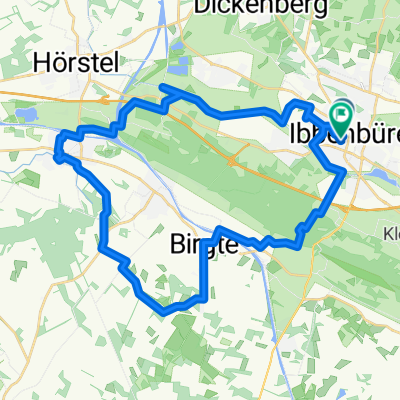
Teuto-Classic-Tour
A cycling route starting in Ibbenbueren, North Rhine-Westphalia, Germany.
Overview
About this route
Alle bekannten Berge und Anstiege(bis 17%) wurden dabei erklommen, wie:
das Bocketal, Heesberg, Col du Telegraph (Grafenstr.), Holperdorp, Urberg, Freeden, Col du MadLienen (Holperdorperstr.), Jägerberg, Cappelner Weg, Sundernstr.(Waldbad), Handal, etc.- -:--
- Duration
- 122.2 km
- Distance
- 703 m
- Ascent
- 703 m
- Descent
- ---
- Avg. speed
- ---
- Max. altitude
Route quality
Waytypes & surfaces along the route
Waytypes
Quiet road
58.7 km
(48 %)
Road
20.8 km
(17 %)
Surfaces
Paved
74.6 km
(61 %)
Unpaved
3.7 km
(3 %)
Asphalt
63.6 km
(52 %)
Paved (undefined)
11 km
(9 %)
Continue with Bikemap
Use, edit, or download this cycling route
You would like to ride Teuto-Classic-Tour or customize it for your own trip? Here is what you can do with this Bikemap route:
Free features
- Save this route as favorite or in collections
- Copy & plan your own version of this route
- Split it into stages to create a multi-day tour
- Sync your route with Garmin or Wahoo
Premium features
Free trial for 3 days, or one-time payment. More about Bikemap Premium.
- Navigate this route on iOS & Android
- Export a GPX / KML file of this route
- Create your custom printout (try it for free)
- Download this route for offline navigation
Discover more Premium features.
Get Bikemap PremiumFrom our community
Other popular routes starting in Ibbenbueren
- Ausfahrt Marathon Ibbenbüren 25.07.2009
- Distance
- 56 km
- Ascent
- 302 m
- Descent
- 302 m
- Location
- Ibbenbueren, North Rhine-Westphalia, Germany
- Tour nördl. Ibbenbüren
- Distance
- 50.5 km
- Ascent
- 156 m
- Descent
- 169 m
- Location
- Ibbenbueren, North Rhine-Westphalia, Germany
- Dickenberg-Bramsche-Dickenberg
- Distance
- 66.7 km
- Ascent
- 163 m
- Descent
- 163 m
- Location
- Ibbenbueren, North Rhine-Westphalia, Germany
- Lagg-FMO-Lagg
- Distance
- 59.5 km
- Ascent
- 227 m
- Descent
- 228 m
- Location
- Ibbenbueren, North Rhine-Westphalia, Germany
- Dickenberg- Recke-Hopsten-Ostenwalde
- Distance
- 35 km
- Ascent
- 115 m
- Descent
- 115 m
- Location
- Ibbenbueren, North Rhine-Westphalia, Germany
- Teutoburgerwaldtocht 85km
- Distance
- 86.5 km
- Ascent
- 960 m
- Descent
- 922 m
- Location
- Ibbenbueren, North Rhine-Westphalia, Germany
- Ibbenbüren 2019
- Distance
- 63.7 km
- Ascent
- 636 m
- Descent
- 635 m
- Location
- Ibbenbueren, North Rhine-Westphalia, Germany
- Teutorundfahrt
- Distance
- 36.5 km
- Ascent
- 135 m
- Descent
- 138 m
- Location
- Ibbenbueren, North Rhine-Westphalia, Germany
Open it in the app