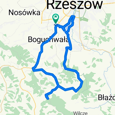
Błotko z Piotrkiem
A cycling route starting in Boguchwała, Subcarpathian Voivodeship, Poland.
Overview
About this route
Route suitable for a bike with a high clearance for mud :D
- -:--
- Duration
- 62.2 km
- Distance
- 412 m
- Ascent
- 410 m
- Descent
- ---
- Avg. speed
- ---
- Max. altitude
Route quality
Waytypes & surfaces along the route
Waytypes
Quiet road
15.6 km
(25 %)
Track
15.6 km
(25 %)
Surfaces
Paved
33 km
(53 %)
Unpaved
10.6 km
(17 %)
Asphalt
29.9 km
(48 %)
Pebblestone
5 km
(8 %)
Route highlights
Points of interest along the route
Point of interest after 13.1 km
I od tego momentu zaczęło się bagno, a skończyło dopiero przy zjeździe do Niechobrza :D
Continue with Bikemap
Use, edit, or download this cycling route
You would like to ride Błotko z Piotrkiem or customize it for your own trip? Here is what you can do with this Bikemap route:
Free features
- Save this route as favorite or in collections
- Copy & plan your own version of this route
- Sync your route with Garmin or Wahoo
Premium features
Free trial for 3 days, or one-time payment. More about Bikemap Premium.
- Navigate this route on iOS & Android
- Export a GPX / KML file of this route
- Create your custom printout (try it for free)
- Download this route for offline navigation
Discover more Premium features.
Get Bikemap PremiumFrom our community
Other popular routes starting in Boguchwała
- Rzeszów - Dąbrówka Starzeńska
- Distance
- 50.4 km
- Ascent
- 607 m
- Descent
- 565 m
- Location
- Boguchwała, Subcarpathian Voivodeship, Poland
- Boguchwała-Wielki Las-Przedmieście Czudeckie-Boguchwała
- Distance
- 39.1 km
- Ascent
- 417 m
- Descent
- 420 m
- Location
- Boguchwała, Subcarpathian Voivodeship, Poland
- Błotko z Piotrkiem
- Distance
- 62.2 km
- Ascent
- 412 m
- Descent
- 410 m
- Location
- Boguchwała, Subcarpathian Voivodeship, Poland
- Dużo terenu za Wilczym
- Distance
- 79.2 km
- Ascent
- 898 m
- Descent
- 903 m
- Location
- Boguchwała, Subcarpathian Voivodeship, Poland
- Szosa - projekt trasy
- Distance
- 46.6 km
- Ascent
- ---
- Descent
- ---
- Location
- Boguchwała, Subcarpathian Voivodeship, Poland
- Skansen Kolbuszowa
- Distance
- 80.2 km
- Ascent
- 168 m
- Descent
- 168 m
- Location
- Boguchwała, Subcarpathian Voivodeship, Poland
- Kwiatkowskiego - Przylasek - Strszydle -
- Distance
- 57.8 km
- Ascent
- 831 m
- Descent
- 830 m
- Location
- Boguchwała, Subcarpathian Voivodeship, Poland
- Kopiec Konfederatow Barskich
- Distance
- 21.1 km
- Ascent
- 95 m
- Descent
- 96 m
- Location
- Boguchwała, Subcarpathian Voivodeship, Poland
Open it in the app