

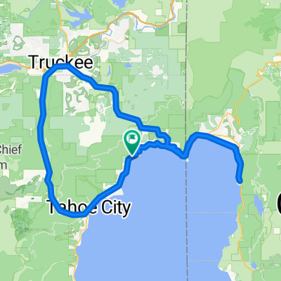
18-Queens Way to past Markleeville
A cycling route starting in Tahoe Vista, California, United States.
Overview
About this route
18 <div id="myEventWatcherDiv" style="display:none;"> </div>
- -:--
- Duration
- 129.2 km
- Distance
- 1,880 m
- Ascent
- 1,498 m
- Descent
- ---
- Avg. speed
- ---
- Max. altitude
Route quality
Waytypes & surfaces along the route
Waytypes
Busy road
87 km
(67 %)
Quiet road
20.7 km
(16 %)
Surfaces
Paved
114.7 km
(89 %)
Unpaved
2.2 km
(2 %)
Asphalt
113.5 km
(88 %)
Ground
1.6 km
(1 %)
Continue with Bikemap
Use, edit, or download this cycling route
You would like to ride 18-Queens Way to past Markleeville or customize it for your own trip? Here is what you can do with this Bikemap route:
Free features
- Save this route as favorite or in collections
- Copy & plan your own version of this route
- Split it into stages to create a multi-day tour
- Sync your route with Garmin or Wahoo
Premium features
Free trial for 3 days, or one-time payment. More about Bikemap Premium.
- Navigate this route on iOS & Android
- Export a GPX / KML file of this route
- Create your custom printout (try it for free)
- Download this route for offline navigation
Discover more Premium features.
Get Bikemap PremiumFrom our community
Other popular routes starting in Tahoe Vista
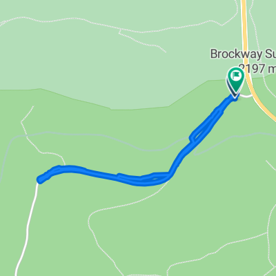
 4100–4110 Coyote Fork, Truckee to 4998 N Lake Blvd, Carnelian Bay
- Distance
- 19.3 km
- Ascent
- 354 m
- Descent
- 427 m
- Location
- Tahoe Vista, California, United States
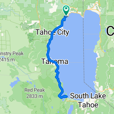
 De 305 Brockway Ct, Tahoe Vista a 305 Brockway Ct, Tahoe Vista
- Distance
- 44.7 km
- Ascent
- 1,144 m
- Descent
- 1,144 m
- Location
- Tahoe Vista, California, United States
 18-Queens Way to past Markleeville
- Distance
- 129.2 km
- Ascent
- 1,880 m
- Descent
- 1,498 m
- Location
- Tahoe Vista, California, United States
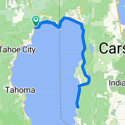
 Lake Tahoe Half Route 1
- Distance
- 92.6 km
- Ascent
- 781 m
- Descent
- 783 m
- Location
- Tahoe Vista, California, United States
 forest road towards dusk
- Distance
- 2.1 km
- Ascent
- 32 m
- Descent
- 41 m
- Location
- Tahoe Vista, California, United States
 Lake Tahoe Half Bike Route 2
- Distance
- 91.7 km
- Ascent
- 848 m
- Descent
- 848 m
- Location
- Tahoe Vista, California, United States
 Lake Tahoe Half Bike Route 3
- Distance
- 91.3 km
- Ascent
- 816 m
- Descent
- 817 m
- Location
- Tahoe Vista, California, United States
 Northstar to part
- Distance
- 51.6 km
- Ascent
- 597 m
- Descent
- 670 m
- Location
- Tahoe Vista, California, United States
Open it in the app