
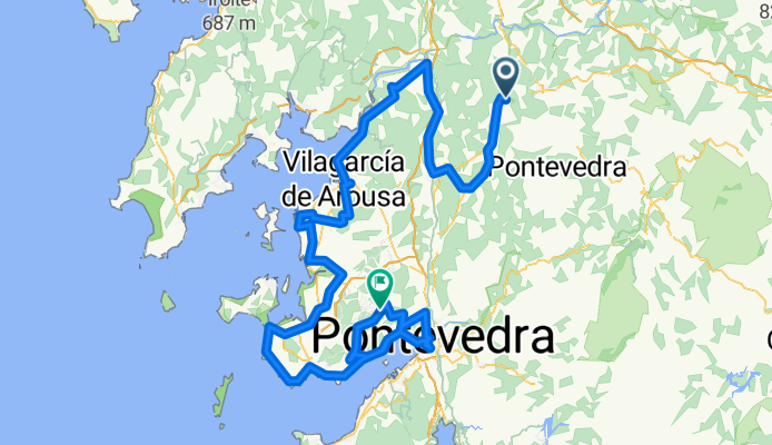
18ª Rep La Astrada , monte Castrove 161,7, km Repasada
A cycling route starting in A Estrada, Galicia, Spain.
Overview
About this route
18th Rep La Estrada, Monte Castrove 161.7 km with some small modifications
- -:--
- Duration
- 161.4 km
- Distance
- 1,659 m
- Ascent
- 1,443 m
- Descent
- ---
- Avg. speed
- ---
- Max. altitude

Route highlights
Points of interest along the route
Point of interest after 14.7 km
Point of interest after 15.1 km
en est punto se va recto
Point of interest after 130.7 km
Continue with Bikemap
Use, edit, or download this cycling route
You would like to ride 18ª Rep La Astrada , monte Castrove 161,7, km Repasada or customize it for your own trip? Here is what you can do with this Bikemap route:
Free features
- Save this route as favorite or in collections
- Copy & plan your own version of this route
- Split it into stages to create a multi-day tour
- Sync your route with Garmin or Wahoo
Premium features
Free trial for 3 days, or one-time payment. More about Bikemap Premium.
- Navigate this route on iOS & Android
- Export a GPX / KML file of this route
- Create your custom printout (try it for free)
- Download this route for offline navigation
Discover more Premium features.
Get Bikemap PremiumFrom our community
Other popular routes starting in A Estrada
 R04A-Ruta longa ó Monte Cabalar e Carballeiras de A Somoza_20 km-OPC1
- Distance
- 19.9 km
- Ascent
- 458 m
- Descent
- 459 m
- Location
- A Estrada, Galicia, Spain
 18ª Rep La Astrada , monte Castrove 161,7, km Repasada
- Distance
- 161.4 km
- Ascent
- 1,659 m
- Descent
- 1,443 m
- Location
- A Estrada, Galicia, Spain
 RUTA A ESTRADA-IROITA
- Distance
- 139.6 km
- Ascent
- 1,679 m
- Descent
- 1,679 m
- Location
- A Estrada, Galicia, Spain
 18ª Rep La Astrada , monte Castrove 157,2 km Repasada
- Distance
- 157.4 km
- Ascent
- 1,540 m
- Descent
- 1,327 m
- Location
- A Estrada, Galicia, Spain
 18ª Etapa Rep La Astrada , monte Castrove 157,2 km Repasada
- Distance
- 171.5 km
- Ascent
- 1,714 m
- Descent
- 1,501 m
- Location
- A Estrada, Galicia, Spain
 RDB071 - Volta por Arca, Liripio e Forcarei
- Distance
- 72 km
- Ascent
- 1,501 m
- Descent
- 1,496 m
- Location
- A Estrada, Galicia, Spain
 RDB66_40 km_A Estrada-Callobre-Rubín-Agar-Orazo-Loimil-Oca-Arnois-Paradela-Aguións-A Estrada
- Distance
- 41.3 km
- Ascent
- 766 m
- Descent
- 766 m
- Location
- A Estrada, Galicia, Spain
 RUTA_058
- Distance
- 76 km
- Ascent
- 1,187 m
- Descent
- 1,190 m
- Location
- A Estrada, Galicia, Spain
Open it in the app