
Gwiazda Wschodu
A cycling route starting in Tereszpol, Lublin Voivodeship, Poland.
Overview
About this route
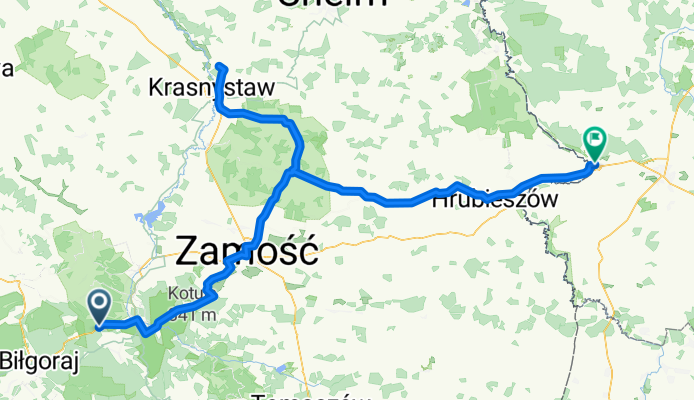
Route to the easternmost point of Poland
- -:--
- Duration
- 182.2 km
- Distance
- 369 m
- Ascent
- 455 m
- Descent
- ---
- Avg. speed
- ---
- Max. altitude
Route quality
Waytypes & surfaces along the route
Waytypes
Road
65.6 km
(36 %)
Track
14.6 km
(8 %)
Surfaces
Paved
142.1 km
(78 %)
Unpaved
7.3 km
(4 %)
Asphalt
142.1 km
(78 %)
Unpaved (undefined)
3.6 km
(2 %)
Continue with Bikemap
Use, edit, or download this cycling route
You would like to ride Gwiazda Wschodu or customize it for your own trip? Here is what you can do with this Bikemap route:
Free features
- Save this route as favorite or in collections
- Copy & plan your own version of this route
- Split it into stages to create a multi-day tour
- Sync your route with Garmin or Wahoo
Premium features
Free trial for 3 days, or one-time payment. More about Bikemap Premium.
- Navigate this route on iOS & Android
- Export a GPX / KML file of this route
- Create your custom printout (try it for free)
- Download this route for offline navigation
Discover more Premium features.
Get Bikemap PremiumFrom our community
Other popular routes starting in Tereszpol
 Gwiazda Wschodu
- Distance
- 182.2 km
- Ascent
- 369 m
- Descent
- 455 m
- Location
- Tereszpol, Lublin Voivodeship, Poland
 Lipowiec
- Distance
- 114.4 km
- Ascent
- 154 m
- Descent
- 256 m
- Location
- Tereszpol, Lublin Voivodeship, Poland
 Hedwiżyn 59A, Biłgoraj do Hedwiżyn 59A, Biłgoraj
- Distance
- 8.2 km
- Ascent
- 131 m
- Descent
- 129 m
- Location
- Tereszpol, Lublin Voivodeship, Poland
 test 2
- Distance
- 22.5 km
- Ascent
- 243 m
- Descent
- 244 m
- Location
- Tereszpol, Lublin Voivodeship, Poland
 Lipiec 3
- Distance
- 76.2 km
- Ascent
- 268 m
- Descent
- 274 m
- Location
- Tereszpol, Lublin Voivodeship, Poland
 Dyle przez Floriankę do Zwierzyńca
- Distance
- 57.3 km
- Ascent
- 605 m
- Descent
- 605 m
- Location
- Tereszpol, Lublin Voivodeship, Poland
 10.08.2019 Roztocze II
- Distance
- 59.1 km
- Ascent
- 204 m
- Descent
- 212 m
- Location
- Tereszpol, Lublin Voivodeship, Poland
 Trasa rowerowa Wzgórze Polak
- Distance
- 45.8 km
- Ascent
- 4 m
- Descent
- 14 m
- Location
- Tereszpol, Lublin Voivodeship, Poland
Open it in the app