

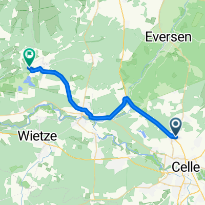
Sonntagsrunde
A cycling route starting in Celle, Lower Saxony, Germany.
Overview
About this route
- -:--
- Duration
- 100.6 km
- Distance
- 224 m
- Ascent
- 221 m
- Descent
- ---
- Avg. speed
- 130 m
- Max. altitude
Route quality
Waytypes & surfaces along the route
Waytypes
Path
35.2 km
(35 %)
Road
8 km
(8 %)
Surfaces
Paved
85.5 km
(85 %)
Unpaved
1 km
(1 %)
Asphalt
80.4 km
(80 %)
Concrete
5 km
(5 %)
Continue with Bikemap
Use, edit, or download this cycling route
You would like to ride Sonntagsrunde or customize it for your own trip? Here is what you can do with this Bikemap route:
Free features
- Save this route as favorite or in collections
- Copy & plan your own version of this route
- Split it into stages to create a multi-day tour
- Sync your route with Garmin or Wahoo
Premium features
Free trial for 3 days, or one-time payment. More about Bikemap Premium.
- Navigate this route on iOS & Android
- Export a GPX / KML file of this route
- Create your custom printout (try it for free)
- Download this route for offline navigation
Discover more Premium features.
Get Bikemap PremiumFrom our community
Other popular routes starting in Celle
 Sonntagsrunde
- Distance
- 100.6 km
- Ascent
- 224 m
- Descent
- 221 m
- Location
- Celle, Lower Saxony, Germany
 Soltau - Blomesche Wildnis
- Distance
- 127.1 km
- Ascent
- 518 m
- Descent
- 530 m
- Location
- Celle, Lower Saxony, Germany
 Scheuener Straße nach Sunder
- Distance
- 23.4 km
- Ascent
- 75 m
- Descent
- 88 m
- Location
- Celle, Lower Saxony, Germany
 Wittingerstr nach oppershausen der Aller entlang
- Distance
- 29.4 km
- Ascent
- 52 m
- Descent
- 51 m
- Location
- Celle, Lower Saxony, Germany
 Kleine Feierabendrunde südl. Celle
- Distance
- 29 km
- Ascent
- 20 m
- Descent
- 22 m
- Location
- Celle, Lower Saxony, Germany
 Celler_radtour_nr_2
- Distance
- 48.7 km
- Ascent
- 119 m
- Descent
- 118 m
- Location
- Celle, Lower Saxony, Germany
 Von Celle bis Bremen über Uelzen Munster Walsrode
- Distance
- 216 km
- Ascent
- 832 m
- Descent
- 864 m
- Location
- Celle, Lower Saxony, Germany
 Spargeltour 2018 Hintour
- Distance
- 27.4 km
- Ascent
- 65 m
- Descent
- 62 m
- Location
- Celle, Lower Saxony, Germany
Open it in the app