
Na kolech zeleným srdcem Srbska
A cycling route starting in Vrnjačka Banja, Central Serbia, Serbia.
Overview
About this route
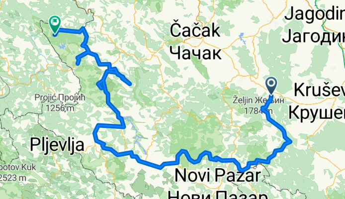
Nechme se unést zeleným Srbskem - nabídne nám plnou náruč příjemných tras pro závodníky i pohodáře. Cesty vinoucí se podél vodních toků, klikatící se rozkvetlými loukami a procházející hlubokými lesy, teprve čekající na houfy turistů, jsou tou pravou volbou pro romantiky na kolech. Zamíříme do národních parků, vystoupáme na nejvyšší srbské vrcholy, nad hlavami nám proletí supi a historické kláštery nás přenesou do minulosti.
- -:--
- Duration
- 445.1 km
- Distance
- 5,573 m
- Ascent
- 5,139 m
- Descent
- ---
- Avg. speed
- ---
- Max. altitude

Route highlights
Points of interest along the route
Point of interest after 11.9 km
Goč
Point of interest after 59.5 km
Brzeče
Point of interest after 143.4 km
Golija
Point of interest after 224.5 km
Prijepolje
Point of interest after 293.8 km
Zlatibor
Point of interest after 330.6 km
Sirogojno
Point of interest after 385.9 km
Mokra Gora
Point of interest after 443.2 km
NP Tara
Continue with Bikemap
Use, edit, or download this cycling route
You would like to ride Na kolech zeleným srdcem Srbska or customize it for your own trip? Here is what you can do with this Bikemap route:
Free features
- Save this route as favorite or in collections
- Copy & plan your own version of this route
- Split it into stages to create a multi-day tour
- Sync your route with Garmin or Wahoo
Premium features
Free trial for 3 days, or one-time payment. More about Bikemap Premium.
- Navigate this route on iOS & Android
- Export a GPX / KML file of this route
- Create your custom printout (try it for free)
- Download this route for offline navigation
Discover more Premium features.
Get Bikemap PremiumFrom our community
Other popular routes starting in Vrnjačka Banja
 Recovered Route
- Distance
- 4.3 km
- Ascent
- 146 m
- Descent
- 15 m
- Location
- Vrnjačka Banja, Central Serbia, Serbia
 5, Вранеши to Karađorđeva, Kraljevo
- Distance
- 40.4 km
- Ascent
- 600 m
- Descent
- 621 m
- Location
- Vrnjačka Banja, Central Serbia, Serbia
 -krusevac
- Distance
- 45.1 km
- Ascent
- 204 m
- Descent
- 363 m
- Location
- Vrnjačka Banja, Central Serbia, Serbia
 Војводе Мишића 14, Врњачка Бања to Руђиначка 67, Врњачка Бања
- Distance
- 25.6 km
- Ascent
- 199 m
- Descent
- 154 m
- Location
- Vrnjačka Banja, Central Serbia, Serbia
 Tour of Serbia 2016 (2.2) Stage 6
- Distance
- 121.2 km
- Ascent
- 625 m
- Descent
- 697 m
- Location
- Vrnjačka Banja, Central Serbia, Serbia
 Slow ride
- Distance
- 3.7 km
- Ascent
- 21 m
- Descent
- 70 m
- Location
- Vrnjačka Banja, Central Serbia, Serbia
 Цара Душана 3, Врњачка Бања to Цара Душана 3, Врњачка Бања
- Distance
- 7.5 km
- Ascent
- 181 m
- Descent
- 181 m
- Location
- Vrnjačka Banja, Central Serbia, Serbia
 Vrnjacka Goc
- Distance
- 21.8 km
- Ascent
- 843 m
- Descent
- 850 m
- Location
- Vrnjačka Banja, Central Serbia, Serbia
Open it in the app