

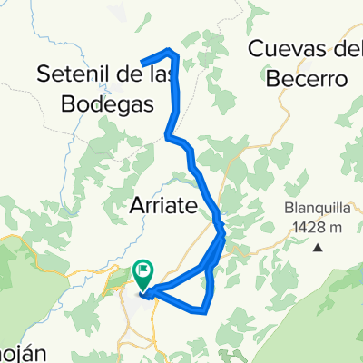
Ronda-Las Palomas-El Boyar-Ronda
A cycling route starting in Ronda, Andalusia, Spain.
Overview
About this route
Ruta muy dura por la Sierra de Cadiz.
- -:--
- Duration
- 150.9 km
- Distance
- 2,680 m
- Ascent
- 2,688 m
- Descent
- ---
- Avg. speed
- ---
- Max. altitude
Route quality
Waytypes & surfaces along the route
Waytypes
Road
88.3 km
(58 %)
Busy road
59.9 km
(40 %)
Surfaces
Paved
66.6 km
(44 %)
Asphalt
66.3 km
(44 %)
Paved (undefined)
0.3 km
(<1 %)
Undefined
84.3 km
(56 %)
Continue with Bikemap
Use, edit, or download this cycling route
You would like to ride Ronda-Las Palomas-El Boyar-Ronda or customize it for your own trip? Here is what you can do with this Bikemap route:
Free features
- Save this route as favorite or in collections
- Copy & plan your own version of this route
- Split it into stages to create a multi-day tour
- Sync your route with Garmin or Wahoo
Premium features
Free trial for 3 days, or one-time payment. More about Bikemap Premium.
- Navigate this route on iOS & Android
- Export a GPX / KML file of this route
- Create your custom printout (try it for free)
- Download this route for offline navigation
Discover more Premium features.
Get Bikemap PremiumFrom our community
Other popular routes starting in Ronda
 Ronda-Grazalema-Zahara-Ronda
- Distance
- 83 km
- Ascent
- 1,470 m
- Descent
- 1,469 m
- Location
- Ronda, Andalusia, Spain
 ANDALUSIA 1 - 25/08/2017
- Distance
- 71.8 km
- Ascent
- 1,006 m
- Descent
- 1,695 m
- Location
- Ronda, Andalusia, Spain
 Ruta Setenil
- Distance
- 46.3 km
- Ascent
- 508 m
- Descent
- 501 m
- Location
- Ronda, Andalusia, Spain
 101 Km Ronda 2008-GR163
- Distance
- 102.7 km
- Ascent
- 1,395 m
- Descent
- 1,395 m
- Location
- Ronda, Andalusia, Spain
 Ronda MTB 40km
- Distance
- 38.2 km
- Ascent
- 497 m
- Descent
- 496 m
- Location
- Ronda, Andalusia, Spain
 Ronda-Setenil
- Distance
- 64.3 km
- Ascent
- 843 m
- Descent
- 839 m
- Location
- Ronda, Andalusia, Spain
 seguimiento 101
- Distance
- 60.7 km
- Ascent
- 765 m
- Descent
- 790 m
- Location
- Ronda, Andalusia, Spain
 Serrato
- Distance
- 69.7 km
- Ascent
- 1,209 m
- Descent
- 1,206 m
- Location
- Ronda, Andalusia, Spain
Open it in the app