

Etapa 4
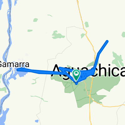
A cycling route starting in Aguachica, Cesar Department, Colombia.
Overview
About this route
Etapa 4
Aguachica - Bosconia Distancia 210.76Km Larga duración terreno plano con algunos repechos.- -:--
- Duration
- 210.8 km
- Distance
- 306 m
- Ascent
- 411 m
- Descent
- ---
- Avg. speed
- ---
- Max. altitude

Continue with Bikemap
Use, edit, or download this cycling route
You would like to ride Etapa 4 or customize it for your own trip? Here is what you can do with this Bikemap route:
Free features
- Save this route as favorite or in collections
- Copy & plan your own version of this route
- Split it into stages to create a multi-day tour
- Sync your route with Garmin or Wahoo
Premium features
Free trial for 3 days, or one-time payment. More about Bikemap Premium.
- Navigate this route on iOS & Android
- Export a GPX / KML file of this route
- Create your custom printout (try it for free)
- Download this route for offline navigation
Discover more Premium features.
Get Bikemap PremiumFrom our community
Other popular routes starting in Aguachica
 Vuelta a Colombia inventada etapa 6 Aguachica- Sardinata
- Distance
- 188.5 km
- Ascent
- 3,061 m
- Descent
- 2,904 m
- Location
- Aguachica, Cesar Department, Colombia
 De Aguachica a Carrera 39 6-52, Aguachica
- Distance
- 64.8 km
- Ascent
- 1,418 m
- Descent
- 1,425 m
- Location
- Aguachica, Cesar Department, Colombia
 Day 7: Aguachica to San Alberto
- Distance
- 70 km
- Ascent
- 394 m
- Descent
- 457 m
- Location
- Aguachica, Cesar Department, Colombia
 De Calle 3-44 a Calle 3-44
- Distance
- 167 km
- Ascent
- 1,572 m
- Descent
- 1,577 m
- Location
- Aguachica, Cesar Department, Colombia
 casa a entrada La estación Gamarra
- Distance
- 26.4 km
- Ascent
- 175 m
- Descent
- 173 m
- Location
- Aguachica, Cesar Department, Colombia
 De Gamarra-Aguachica a Calle 7 7-116, Aguachica
- Distance
- 9.7 km
- Ascent
- 67 m
- Descent
- 52 m
- Location
- Aguachica, Cesar Department, Colombia
 Aguachica - Curumani
- Distance
- 113 km
- Ascent
- 306 m
- Descent
- 430 m
- Location
- Aguachica, Cesar Department, Colombia
 De Carrera 20 478, Aguachica a Unnamed Road, Ocaña
- Distance
- 56.3 km
- Ascent
- 2,352 m
- Descent
- 1,329 m
- Location
- Aguachica, Cesar Department, Colombia
Open it in the app