

Hillsdale Ramble
A cycling route starting in Union, West Virginia, United States.
Overview
About this route
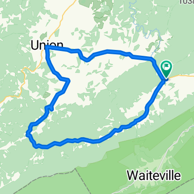
Rolling ride thru karst terrain of Monroe County. Start at Sinks Grove Baptist Church
0.0 0.0 Right out of church parking lot. 3.0 3.0 Left 58/1 Longanacre Road 5.0 2.0 Right on 58 5.9 0.9 Right on 43 8.8 2.9 Left on 5/1 9.6 0.8 Right on 5/3 9.7 0.1 Right on 5/3 11.0 1.3 Pass entrance to Morgan Orchard. 11.2 0.2 Right on 219/3 13.6 2.4 Right on 219 13.9 0.3 Right on 219/4 14.6 0.7 Bare right on 11/1 16.9 2.3 Right on Cty 11 Hillsdale Rd. Short steep climb. 17.1 0.2 Right on 219/5 19.7 2.6 Right on US 219 20.4 0.7 Left on 3/6 Stumptown Rd. 23.6 3.2 Left on State 3 24.6 1.0 Right on Cty. 5 24.8 0.2 Left on 5/5 25.2 0.4 Left on Cty. 5 25.6 0.4 Left on 5/2 25.7 0.1 Finish - -:--
- Duration
- 41.5 km
- Distance
- 398 m
- Ascent
- 398 m
- Descent
- ---
- Avg. speed
- ---
- Max. altitude
Continue with Bikemap
Use, edit, or download this cycling route
You would like to ride Hillsdale Ramble or customize it for your own trip? Here is what you can do with this Bikemap route:
Free features
- Save this route as favorite or in collections
- Copy & plan your own version of this route
- Sync your route with Garmin or Wahoo
Premium features
Free trial for 3 days, or one-time payment. More about Bikemap Premium.
- Navigate this route on iOS & Android
- Export a GPX / KML file of this route
- Create your custom printout (try it for free)
- Download this route for offline navigation
Discover more Premium features.
Get Bikemap PremiumFrom our community
Other popular routes starting in Union
 Zenith - Willow Bend Loop
- Distance
- 41.4 km
- Ascent
- 470 m
- Descent
- 470 m
- Location
- Union, West Virginia, United States
 Wikel Loop
- Distance
- 33.4 km
- Ascent
- 424 m
- Descent
- 423 m
- Location
- Union, West Virginia, United States
 Lower Johnsons Crossroads Loop.
- Distance
- 37 km
- Ascent
- 1,576 m
- Descent
- 1,657 m
- Location
- Union, West Virginia, United States
 Greenville Long Loop Via 219
- Distance
- 45.2 km
- Ascent
- 524 m
- Descent
- 522 m
- Location
- Union, West Virginia, United States
 Hillsdale Ramble
- Distance
- 41.5 km
- Ascent
- 398 m
- Descent
- 398 m
- Location
- Union, West Virginia, United States
 Gap Mills Loop
- Distance
- 59.4 km
- Ascent
- 828 m
- Descent
- 828 m
- Location
- Union, West Virginia, United States
 Zenith Loop
- Distance
- 45.3 km
- Ascent
- 503 m
- Descent
- 503 m
- Location
- Union, West Virginia, United States
 Tour de Sinks
- Distance
- 46.2 km
- Ascent
- 400 m
- Descent
- 400 m
- Location
- Union, West Virginia, United States
Open it in the app