

Gran Tour Finale
A cycling route starting in Finale Ligure, Liguria, Italy.
Overview
About this route
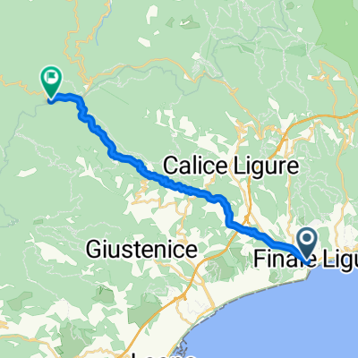
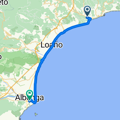
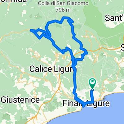
Starting from Finalpia, continue on Via Aurelia heading west until the junction to loc. San Bernardino, where you turn right (wp002) and begin climbing on asphalt following the "SPORTING CLUB" signs. Continue climbing until you reach Via degli Alisei, where a dirt path begins that over about 1 km of ups and downs leads to the start of the "DOLMEN" trail. Here begins a beautiful, sometimes technical descent, always taking right forks, leading to Final Borgo. After crossing the Torrente Aquila, turn right (wp012) onto Via Sottoripa, better known as the "Sentiero dei lavatoi". Upon entering the village of Finale, keep right and begin climbing technical but rideable stairs (...not for everyone ;-) ) to reconnect with the cobblestone path leading to the slopes of Castel Gavone with steep but still rideable ramps. Pass the castle on your left until reaching Perti (wp016), where there is a potable water fountain. Continue towards Case Valle on asphalt until reaching the Monte Sordo parking (wp017). Take the cobblestone path downhill towards Calice (ONO), and after about 200 m, turn right onto the trail that emerges onto Via Olive. Continue on asphalt for a few hundred meters then turn right and take Via Dante Alighieri uphill. Now follow the "red triangle" trail marker, first on steep asphalt ramps then dirt paths with maximum gradients of 28% !!!! and an average gradient of 9%. Upon reaching the hilltop, continue on the main dirt road for about 700 m. At a clearing, be careful to take the downhill trail (wp020) called "La Legnaia": 5 minutes and 800 m of pure fun with technical and flowing sections where the absolute rule is to let go of the brakes! Upon reaching the main dirt road, turn left and after a few dozen meters turn left onto the "+" trail to be walked uphill alongside your bike initially, then becoming a bit more rideable higher up. After some effort, you reach the asphalt road that leads from Carbuta towards Melogno. Take it uphill towards Melogno and suffer (now a little less) for another 1.5 km until reaching the start of the longest (and perhaps most fun) downhill trail of the day: Pian Merlino right variant. 2.2 km with 340 m descent that leaves you breathless. Upon reaching the village of Feglino, you can refresh yourself at the village bar or decide to immediately climb towards Orco on the provincial road (3 km, 180 m ascent). In Orco, descend a few hundred meters on asphalt to reach the ruins of the San Lorenzo church. The original idea to finish the loop and return to Final Pia was to take the Ciappi trail in reverse direction and then do the Ruggetta trail downhill to Calvisio. The effort of a day partly spent pushing bikes under heavy snowflakes and icy wind enlightened us, giving us the idea to ride the beautiful and almost entirely rideable trail that skirts the west side of Monte Cucco "red diamond" trail marker and takes us back to Bric Pianarella until the start of the last exciting descent of the "Ruggetta" (3.5 km, -310 m elevation). The GRAN TOUR FINALE in summer version still needs to be perfected to reach 2000 m elevation gain and to touch other exciting areas of the Ligurian MTB mecca, thus completing an encyclopedic tour of the trails of the Finalese area.
- -:--
- Duration
- 34.7 km
- Distance
- 1,184 m
- Ascent
- 1,184 m
- Descent
- ---
- Avg. speed
- ---
- Max. altitude

Continue with Bikemap
Use, edit, or download this cycling route
You would like to ride Gran Tour Finale or customize it for your own trip? Here is what you can do with this Bikemap route:
Free features
- Save this route as favorite or in collections
- Copy & plan your own version of this route
- Sync your route with Garmin or Wahoo
Premium features
Free trial for 3 days, or one-time payment. More about Bikemap Premium.
- Navigate this route on iOS & Android
- Export a GPX / KML file of this route
- Create your custom printout (try it for free)
- Download this route for offline navigation
Discover more Premium features.
Get Bikemap PremiumFrom our community
Other popular routes starting in Finale Ligure
 PASSO DI MELOGNO, por Finale Ligure
- Distance
- 16.7 km
- Ascent
- 1,494 m
- Descent
- 466 m
- Location
- Finale Ligure, Liguria, Italy
 Route 2
- Distance
- 26.9 km
- Ascent
- 732 m
- Descent
- 732 m
- Location
- Finale Ligure, Liguria, Italy
 Camping San Martino, Finale ligure nach Camping San Martino, Finale ligure
- Distance
- 21.1 km
- Ascent
- 424 m
- Descent
- 478 m
- Location
- Finale Ligure, Liguria, Italy
 Gran Tour Finale
- Distance
- 34.7 km
- Ascent
- 1,184 m
- Descent
- 1,184 m
- Location
- Finale Ligure, Liguria, Italy
 Via Domenico Brunenghi, Finale Ligure a Via Piave, Albenga
- Distance
- 23 km
- Ascent
- 47 m
- Descent
- 54 m
- Location
- Finale Ligure, Liguria, Italy
 San Filippo - Manie Terre Rosse - Noli
- Distance
- 35.2 km
- Ascent
- 671 m
- Descent
- 672 m
- Location
- Finale Ligure, Liguria, Italy
 Helicopter - Finale Ligure
- Distance
- 44.6 km
- Ascent
- 1,160 m
- Descent
- 1,160 m
- Location
- Finale Ligure, Liguria, Italy
 Etappe 10
- Distance
- 33.9 km
- Ascent
- 524 m
- Descent
- 485 m
- Location
- Finale Ligure, Liguria, Italy
Open it in the app