

RANDO SAINT SULPICE
A cycling route starting in Cognin, Auvergne-Rhône-Alpes, France.
Overview
About this route
RIDE TO ST SULPICE
- -:--
- Duration
- 14.9 km
- Distance
- 532 m
- Ascent
- 535 m
- Descent
- ---
- Avg. speed
- ---
- Max. altitude
Route highlights
Points of interest along the route
Point of interest after 2 km
le parc du Forezan

Point of interest after 6 km
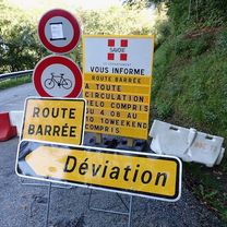
GORGES !

Point of interest after 7.1 km
SOURCE DU FOREZAN 610m attention : photo inexacte !

Point of interest after 8.9 km
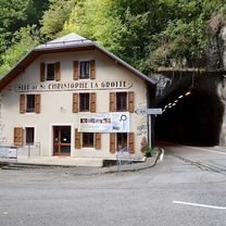
l'église de st sulpice

Point of interest after 9.9 km

Point of interest after 11 km

Point of interest after 11.6 km
LE BON PAS
Continue with Bikemap
Use, edit, or download this cycling route
You would like to ride RANDO SAINT SULPICE or customize it for your own trip? Here is what you can do with this Bikemap route:
Free features
- Save this route as favorite or in collections
- Copy & plan your own version of this route
- Sync your route with Garmin or Wahoo
Premium features
Free trial for 3 days, or one-time payment. More about Bikemap Premium.
- Navigate this route on iOS & Android
- Export a GPX / KML file of this route
- Create your custom printout (try it for free)
- Download this route for offline navigation
Discover more Premium features.
Get Bikemap PremiumFrom our community
Other popular routes starting in Cognin
 Le Tour De France: Stage 11
- Distance
- 177.7 km
- Ascent
- 5,240 m
- Descent
- 3,210 m
- Location
- Cognin, Auvergne-Rhône-Alpes, France
 4 COLS CHARTREUSE 24/03/2015
- Distance
- 57.8 km
- Ascent
- 1,479 m
- Descent
- 1,477 m
- Location
- Cognin, Auvergne-Rhône-Alpes, France
 RANDO SAINT SULPICE
- Distance
- 14.9 km
- Ascent
- 532 m
- Descent
- 535 m
- Location
- Cognin, Auvergne-Rhône-Alpes, France
 STB_Barca_act_007_0811_Chambery - Valence
- Distance
- 130.1 km
- Ascent
- 716 m
- Descent
- 881 m
- Location
- Cognin, Auvergne-Rhône-Alpes, France
 Chambéry - Circle toward Col du Granier
- Distance
- 23.4 km
- Ascent
- 670 m
- Descent
- 673 m
- Location
- Cognin, Auvergne-Rhône-Alpes, France
 VTT SAINT SULPICE
- Distance
- 27.1 km
- Ascent
- 0 m
- Descent
- 0 m
- Location
- Cognin, Auvergne-Rhône-Alpes, France
 Chambéry to Voreppe
- Distance
- 47.2 km
- Ascent
- 870 m
- Descent
- 938 m
- Location
- Cognin, Auvergne-Rhône-Alpes, France
 bauges VTT
- Distance
- 591.1 km
- Ascent
- 7,630 m
- Descent
- 7,559 m
- Location
- Cognin, Auvergne-Rhône-Alpes, France
Open it in the app