
Slovenie, 2 oktober 2013, Podcetrtek-Novo Mesto
A cycling route starting in Podčetrtek, Občina Podčetrtek, Slovenia.
Overview
About this route
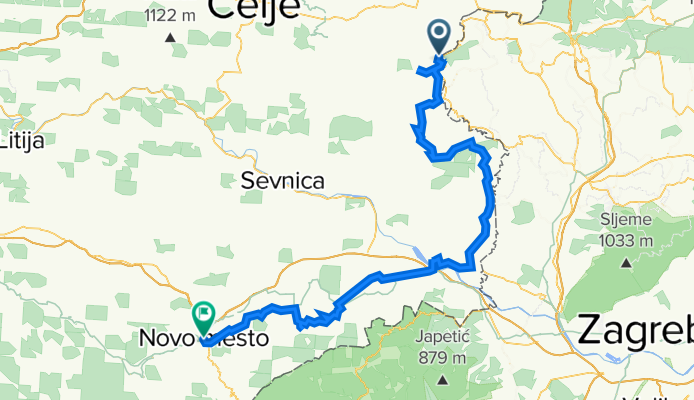
From Podčetrtek a ride with a substantial climb to Olimje. Then back to the main road and follow it to the Buce turnoff. There a quiet country road with a significant climb to Buce followed by a descent to Podsreda. After Podsreda, another tough climb, then descend to the main road at Bistrica. Then another long climb and descent to Brezovica. The last stretch to Brezice is along quiet, fairly flat country roads via Kapele. From Brezice, almost flat on the main road to Kostanjevica, then a steep climb on a country road and a descent towards Smarje. Finally, at Šentjernej, back on the main road to Novo Mesto. This last part is gently hilly.
- -:--
- Duration
- 112 km
- Distance
- 852 m
- Ascent
- 876 m
- Descent
- ---
- Avg. speed
- ---
- Max. altitude
Route quality
Waytypes & surfaces along the route
Waytypes
Road
30.3 km
(27 %)
Quiet road
16.8 km
(15 %)
Surfaces
Paved
57.1 km
(51 %)
Unpaved
2.2 km
(2 %)
Asphalt
57.1 km
(51 %)
Gravel
2.2 km
(2 %)
Undefined
52.7 km
(47 %)
Continue with Bikemap
Use, edit, or download this cycling route
You would like to ride Slovenie, 2 oktober 2013, Podcetrtek-Novo Mesto or customize it for your own trip? Here is what you can do with this Bikemap route:
Free features
- Save this route as favorite or in collections
- Copy & plan your own version of this route
- Split it into stages to create a multi-day tour
- Sync your route with Garmin or Wahoo
Premium features
Free trial for 3 days, or one-time payment. More about Bikemap Premium.
- Navigate this route on iOS & Android
- Export a GPX / KML file of this route
- Create your custom printout (try it for free)
- Download this route for offline navigation
Discover more Premium features.
Get Bikemap PremiumFrom our community
Other popular routes starting in Podčetrtek
 Olimje - Boč - Olimje
- Distance
- 71.9 km
- Ascent
- 1,132 m
- Descent
- 1,134 m
- Location
- Podčetrtek, Občina Podčetrtek, Slovenia
 Olimje blato tour
- Distance
- 63.2 km
- Ascent
- 400 m
- Descent
- 577 m
- Location
- Podčetrtek, Občina Podčetrtek, Slovenia
 Cesta na grad 37, Podčetrtek to Olimje 90, Podčetrtek
- Distance
- 9.3 km
- Ascent
- 432 m
- Descent
- 476 m
- Location
- Podčetrtek, Občina Podčetrtek, Slovenia
 Tour Slo 2023_1
- Distance
- 47.5 km
- Ascent
- 896 m
- Descent
- 853 m
- Location
- Podčetrtek, Občina Podčetrtek, Slovenia
 Renato olimlje - kozje olimje
- Distance
- 35.1 km
- Ascent
- 436 m
- Descent
- 555 m
- Location
- Podčetrtek, Občina Podčetrtek, Slovenia
 Slovenie, 2 oktober 2013, Podcetrtek-Novo Mesto
- Distance
- 112 km
- Ascent
- 852 m
- Descent
- 876 m
- Location
- Podčetrtek, Občina Podčetrtek, Slovenia
 2006 Akul SLO 4.dan (Podčetrtek - Laze pri Predgradu)
- Distance
- 172.2 km
- Ascent
- 1,536 m
- Descent
- 1,586 m
- Location
- Podčetrtek, Občina Podčetrtek, Slovenia
 Tour Slo 2023
- Distance
- 85.6 km
- Ascent
- 1,312 m
- Descent
- 1,347 m
- Location
- Podčetrtek, Občina Podčetrtek, Slovenia
Open it in the app