

wilkowyje
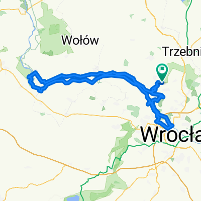
A cycling route starting in Oborniki Śląskie, Lower Silesian Voivodeship, Poland.
Overview
About this route
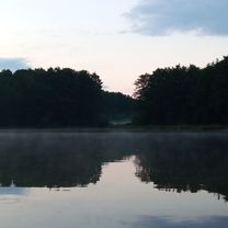
At one point, you need to carry the bike across the tracks. Besides that, the part of the road through the forests at the beginning of the route may differ from the 'real version'.
- -:--
- Duration
- 28.2 km
- Distance
- 188 m
- Ascent
- 186 m
- Descent
- ---
- Avg. speed
- ---
- Max. altitude
Route quality
Waytypes & surfaces along the route
Waytypes
Track
11.6 km
(41 %)
Road
6.8 km
(24 %)
Surfaces
Paved
11.8 km
(42 %)
Unpaved
8.2 km
(29 %)
Asphalt
11.8 km
(42 %)
Unpaved (undefined)
3.9 km
(14 %)
Continue with Bikemap
Use, edit, or download this cycling route
You would like to ride wilkowyje or customize it for your own trip? Here is what you can do with this Bikemap route:
Free features
- Save this route as favorite or in collections
- Copy & plan your own version of this route
- Sync your route with Garmin or Wahoo
Premium features
Free trial for 3 days, or one-time payment. More about Bikemap Premium.
- Navigate this route on iOS & Android
- Export a GPX / KML file of this route
- Create your custom printout (try it for free)
- Download this route for offline navigation
Discover more Premium features.
Get Bikemap PremiumFrom our community
Other popular routes starting in Oborniki Śląskie
 Wycieczka nr 5.
- Distance
- 10.3 km
- Ascent
- 212 m
- Descent
- 185 m
- Location
- Oborniki Śląskie, Lower Silesian Voivodeship, Poland
 drogą Stumilowego Lasu
- Distance
- 19.7 km
- Ascent
- 61 m
- Descent
- 60 m
- Location
- Oborniki Śląskie, Lower Silesian Voivodeship, Poland
 Wycieczka nr 1.
- Distance
- 11.3 km
- Ascent
- 288 m
- Descent
- 252 m
- Location
- Oborniki Śląskie, Lower Silesian Voivodeship, Poland
 Grębocice 2024 (9-10.03)
- Distance
- 162.2 km
- Ascent
- 654 m
- Descent
- 742 m
- Location
- Oborniki Śląskie, Lower Silesian Voivodeship, Poland
 LGD-Pieszy - żółty szlak
- Distance
- 18.4 km
- Ascent
- 22 m
- Descent
- 20 m
- Location
- Oborniki Śląskie, Lower Silesian Voivodeship, Poland
 Wieczka nr 3.
- Distance
- 7.5 km
- Ascent
- 194 m
- Descent
- 195 m
- Location
- Oborniki Śląskie, Lower Silesian Voivodeship, Poland
 Wycieczka nr 4.
- Distance
- 27 km
- Ascent
- 471 m
- Descent
- 508 m
- Location
- Oborniki Śląskie, Lower Silesian Voivodeship, Poland
 Route in Wisznia Mała
- Distance
- 123.3 km
- Ascent
- 318 m
- Descent
- 318 m
- Location
- Oborniki Śląskie, Lower Silesian Voivodeship, Poland
Open it in the app