

Taki tam rozruch :)
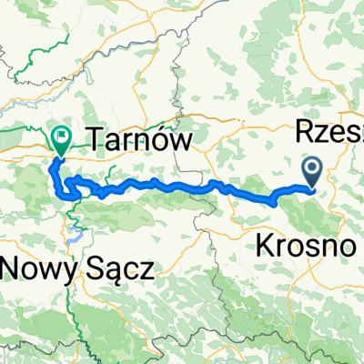
A cycling route starting in Strzyżów, Subcarpathian Voivodeship, Poland.
Overview
About this route
Strzyżów, Czudec, Babica, Rzeszów, Niechobrz, Strzyżów
- -:--
- Duration
- 68.3 km
- Distance
- 520 m
- Ascent
- 520 m
- Descent
- ---
- Avg. speed
- ---
- Max. altitude
Route quality
Waytypes & surfaces along the route
Waytypes
Road
48.5 km
(71 %)
Path
6.8 km
(10 %)
Surfaces
Paved
61.5 km
(90 %)
Unpaved
1.4 km
(2 %)
Asphalt
58.7 km
(86 %)
Paved (undefined)
1.4 km
(2 %)
Continue with Bikemap
Use, edit, or download this cycling route
You would like to ride Taki tam rozruch :) or customize it for your own trip? Here is what you can do with this Bikemap route:
Free features
- Save this route as favorite or in collections
- Copy & plan your own version of this route
- Sync your route with Garmin or Wahoo
Premium features
Free trial for 3 days, or one-time payment. More about Bikemap Premium.
- Navigate this route on iOS & Android
- Export a GPX / KML file of this route
- Create your custom printout (try it for free)
- Download this route for offline navigation
Discover more Premium features.
Get Bikemap PremiumFrom our community
Other popular routes starting in Strzyżów
 HOBBY Cyklokarpaty.pl Strzyżów 2016
- Distance
- 20 km
- Ascent
- 388 m
- Descent
- 393 m
- Location
- Strzyżów, Subcarpathian Voivodeship, Poland
 Strzyżów- Brzesko
- Distance
- 133.1 km
- Ascent
- 1,381 m
- Descent
- 1,338 m
- Location
- Strzyżów, Subcarpathian Voivodeship, Poland
 Strzyżów- Brzesko
- Distance
- 135.5 km
- Ascent
- 759 m
- Descent
- 758 m
- Location
- Strzyżów, Subcarpathian Voivodeship, Poland
 trasa treningowa 1
- Distance
- 12.7 km
- Ascent
- 286 m
- Descent
- 312 m
- Location
- Strzyżów, Subcarpathian Voivodeship, Poland
 Czarnorzecko - Strzyżowski Park Krajobrazowy
- Distance
- 71 km
- Ascent
- 343 m
- Descent
- 343 m
- Location
- Strzyżów, Subcarpathian Voivodeship, Poland
 Taki tam rozruch :)
- Distance
- 68.3 km
- Ascent
- 520 m
- Descent
- 520 m
- Location
- Strzyżów, Subcarpathian Voivodeship, Poland
 Hobby strzyżów
- Distance
- 18.4 km
- Ascent
- 479 m
- Descent
- 480 m
- Location
- Strzyżów, Subcarpathian Voivodeship, Poland
 Godowska Góra
- Distance
- 19.4 km
- Ascent
- 421 m
- Descent
- 417 m
- Location
- Strzyżów, Subcarpathian Voivodeship, Poland
Open it in the app