

Barra de Valizas - Punta del Diablo
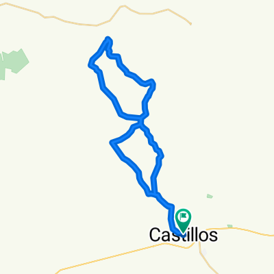
A cycling route starting in Castillos, Rocha Department, Uruguay.
Overview
About this route
Ninth first section. Uruguayan coast.
- -:--
- Duration
- 57.5 km
- Distance
- 179 m
- Ascent
- 149 m
- Descent
- ---
- Avg. speed
- ---
- Max. altitude
Route quality
Waytypes & surfaces along the route
Waytypes
Cycleway
31.6 km
(55 %)
Road
13.2 km
(23 %)
Surfaces
Paved
52.9 km
(92 %)
Unpaved
2.9 km
(5 %)
Asphalt
52.9 km
(92 %)
Unpaved (undefined)
1.7 km
(3 %)
Continue with Bikemap
Use, edit, or download this cycling route
You would like to ride Barra de Valizas - Punta del Diablo or customize it for your own trip? Here is what you can do with this Bikemap route:
Free features
- Save this route as favorite or in collections
- Copy & plan your own version of this route
- Sync your route with Garmin or Wahoo
Premium features
Free trial for 3 days, or one-time payment. More about Bikemap Premium.
- Navigate this route on iOS & Android
- Export a GPX / KML file of this route
- Create your custom printout (try it for free)
- Download this route for offline navigation
Discover more Premium features.
Get Bikemap PremiumFrom our community
Other popular routes starting in Castillos
 Ruta 16 - Fransisco de los Santos/Camino de los Indios
- Distance
- 49.2 km
- Ascent
- 426 m
- Descent
- 395 m
- Location
- Castillos, Rocha Department, Uruguay
 Castillos Curral Alto
- Distance
- 168.6 km
- Ascent
- 99 m
- Descent
- 130 m
- Location
- Castillos, Rocha Department, Uruguay
 De ¿èNÿ? a ¿èNÿ?
- Distance
- 16.9 km
- Ascent
- 100 m
- Descent
- 120 m
- Location
- Castillos, Rocha Department, Uruguay
 BAJADA MALA - HOMBRES
- Distance
- 50.5 km
- Ascent
- 465 m
- Descent
- 465 m
- Location
- Castillos, Rocha Department, Uruguay
 Arenas Doradas 452, Aguas Dulces a Arenas Doradas 976, Aguas Dulces
- Distance
- 2.1 km
- Ascent
- 0 m
- Descent
- 0 m
- Location
- Castillos, Rocha Department, Uruguay
 De M. González 8, Sección 04 a Luis Fabregat, Sección 04
- Distance
- 17.6 km
- Ascent
- 249 m
- Descent
- 254 m
- Location
- Castillos, Rocha Department, Uruguay
 BAJADA MALA 2013
- Distance
- 62.2 km
- Ascent
- 603 m
- Descent
- 600 m
- Location
- Castillos, Rocha Department, Uruguay
 BAJADA MALA
- Distance
- 39.7 km
- Ascent
- 434 m
- Descent
- 434 m
- Location
- Castillos, Rocha Department, Uruguay
Open it in the app