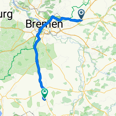
HJ_Rundtour
A cycling route starting in Sottrum, Lower Saxony, Germany.
Overview
About this route
Sottrum-Ressum-Taaken-Winekldorf-Nartum-Mulmshorn-Schleessel-Höperhöfen-Jeerhof-Waffensen-Hassendorf-Sottrum-HJ
- -:--
- Duration
- 38.6 km
- Distance
- 52 m
- Ascent
- 53 m
- Descent
- ---
- Avg. speed
- ---
- Avg. speed
Route quality
Waytypes & surfaces along the route
Waytypes
Quiet road
18.4 km
(48 %)
Road
16.1 km
(42 %)
Surfaces
Paved
16.9 km
(44 %)
Unpaved
0.6 km
(2 %)
Asphalt
9.2 km
(24 %)
Paved (undefined)
7.6 km
(20 %)
Continue with Bikemap
Use, edit, or download this cycling route
You would like to ride HJ_Rundtour or customize it for your own trip? Here is what you can do with this Bikemap route:
Free features
- Save this route as favorite or in collections
- Copy & plan your own version of this route
- Sync your route with Garmin or Wahoo
Premium features
Free trial for 3 days, or one-time payment. More about Bikemap Premium.
- Navigate this route on iOS & Android
- Export a GPX / KML file of this route
- Create your custom printout (try it for free)
- Download this route for offline navigation
Discover more Premium features.
Get Bikemap PremiumFrom our community
Other popular routes starting in Sottrum
- Sottrum und umzu
- Distance
- 40 km
- Ascent
- 88 m
- Descent
- 89 m
- Location
- Sottrum, Lower Saxony, Germany
- Kräuterroute durch die Wiesteniederung
- Distance
- 52 km
- Ascent
- 69 m
- Descent
- 69 m
- Location
- Sottrum, Lower Saxony, Germany
- K204, Sottrum to Borgfelder Heerstraße 38, Bremen
- Distance
- 26.1 km
- Ascent
- 72 m
- Descent
- 90 m
- Location
- Sottrum, Lower Saxony, Germany
- Pfingsten 16 Km Wieste
- Distance
- 16 km
- Ascent
- 31 m
- Descent
- 33 m
- Location
- Sottrum, Lower Saxony, Germany
- Pfingsten2020Bitterstedt Taaken
- Distance
- 16.8 km
- Ascent
- 29 m
- Descent
- 30 m
- Location
- Sottrum, Lower Saxony, Germany
- Pfingsten2
- Distance
- 18.2 km
- Ascent
- 58 m
- Descent
- 60 m
- Location
- Sottrum, Lower Saxony, Germany
- 2015-Tag01
- Distance
- 69.2 km
- Ascent
- 127 m
- Descent
- 144 m
- Location
- Sottrum, Lower Saxony, Germany
- Sottrum Waffensen Ahausen Sottrum
- Distance
- 21.3 km
- Ascent
- 150 m
- Descent
- 150 m
- Location
- Sottrum, Lower Saxony, Germany
Open it in the app