

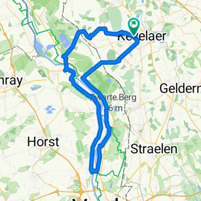
Big Challenge 2023 am Niederrhein "Sonsbecker Schweiz bis zu den Römern"
A cycling route starting in Kevelaer, North Rhine-Westphalia, Germany.
Overview
About this route
- -:--
- Duration
- 46.5 km
- Distance
- 302 m
- Ascent
- 301 m
- Descent
- ---
- Avg. speed
- 82 m
- Max. altitude
Route quality
Waytypes & surfaces along the route
Waytypes
Quiet road
20.5 km
(44 %)
Road
12.1 km
(26 %)
Surfaces
Paved
34.9 km
(75 %)
Asphalt
33.5 km
(72 %)
Paved (undefined)
1.4 km
(3 %)
Undefined
11.6 km
(25 %)
Route highlights
Points of interest along the route

Point of interest after 11.4 km
Versorgungspunkt "Landfrauen Labbeck, Marienbaumerstraße"

Point of interest after 26.3 km
Verpflegung "Am Heesweg"

Point of interest after 32.2 km
Verpflegung "op den Hövel"

Point of interest after 36.7 km
Verpflegung "an der Wiegenstraße 102"
Point of interest after 43.5 km
Big Challenge 2023 Hof Biedemann Start + Ziel
Continue with Bikemap
Use, edit, or download this cycling route
You would like to ride Big Challenge 2023 am Niederrhein "Sonsbecker Schweiz bis zu den Römern" or customize it for your own trip? Here is what you can do with this Bikemap route:
Free features
- Save this route as favorite or in collections
- Copy & plan your own version of this route
- Sync your route with Garmin or Wahoo
Premium features
Free trial for 3 days, or one-time payment. More about Bikemap Premium.
- Navigate this route on iOS & Android
- Export a GPX / KML file of this route
- Create your custom printout (try it for free)
- Download this route for offline navigation
Discover more Premium features.
Get Bikemap PremiumFrom our community
Other popular routes starting in Kevelaer
 Ausfahrt über Wenn
- Distance
- 20.4 km
- Ascent
- 29 m
- Descent
- 30 m
- Location
- Kevelaer, North Rhine-Westphalia, Germany
 Geht das auch ?
- Distance
- 203.7 km
- Ascent
- 155 m
- Descent
- 157 m
- Location
- Kevelaer, North Rhine-Westphalia, Germany
 An der Maas entlang
- Distance
- 59.7 km
- Ascent
- 61 m
- Descent
- 60 m
- Location
- Kevelaer, North Rhine-Westphalia, Germany
 Ich will "" MEER ""
- Distance
- 239.8 km
- Ascent
- 38 m
- Descent
- 61 m
- Location
- Kevelaer, North Rhine-Westphalia, Germany
 Photo Safari mit Mölle
- Distance
- 150.8 km
- Ascent
- 83 m
- Descent
- 86 m
- Location
- Kevelaer, North Rhine-Westphalia, Germany
 Twisteden, Well, Witte Vennen, Broekhuizen
- Distance
- 51.6 km
- Ascent
- 77 m
- Descent
- 77 m
- Location
- Kevelaer, North Rhine-Westphalia, Germany
 Niederrhein Tour
- Distance
- 164.2 km
- Ascent
- 117 m
- Descent
- 117 m
- Location
- Kevelaer, North Rhine-Westphalia, Germany
 500 Km pures vergnügen
- Distance
- 482.5 km
- Ascent
- 175 m
- Descent
- 175 m
- Location
- Kevelaer, North Rhine-Westphalia, Germany
Open it in the app