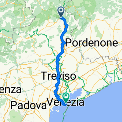
Tour de Barcelona 2014 dzień 11
A cycling route starting in Ponte nelle Alpi, Veneto, Italy.
Overview
About this route
DAY 11 (165 km, approx. 340 m)
Ponte Nelle Alpi – Levego – Visome – Limana – Ponte Ardo – Mel – Gus – Campo San Pietro – Bardies – Lentiai – Villiapiana – Molinello – Marziai – Case Masetti – Scalon – Vas – Fener – Strade Nouve – Fusere Tuna – Quattro Strade – Crespano del Grappa (Via Molinetto) – Sant’Eualia – Romano D’ezzelino (Roma) – BASSANO DEL GRAPPA (Viale Vincenza-Strada Marchessane-SP52) – Roberti-Rivarotta – NOVE (SP52) – Inorocio Tonellotto – Santa Romana – Rancaglia Vaccheria – Scaldaferro (SP52-SP51) – Bressanvido – Poianella – Bolzano Vincentino – Baracchino (Via Tergola-Via Ponte) – Villaggio Acque – Anconetta – VINCENZA (SR11) – Tavernelle – Signolo – Ca’Sordis – Fracanzana – Torri di Confine – SAN BONIFACIO (SR11) – Castelletto – Caldiero – Vago – SAN MARTINO BUON ALBERGO (SR11-Viale del Lavoro-Via Serena-Via Zeviana-Via Pontara Sandri) – Piscine Monte Bianco (Via Compagnole-Via Buri Bernini right turn to the Adige river) – Piscine Monte Bianco (Adige riverbank)
- -:--
- Duration
- 165.9 km
- Distance
- 287 m
- Ascent
- 610 m
- Descent
- ---
- Avg. speed
- ---
- Max. altitude
Route quality
Waytypes & surfaces along the route
Waytypes
Quiet road
18.2 km
(11 %)
Road
14.9 km
(9 %)
Surfaces
Paved
141 km
(85 %)
Unpaved
1.7 km
(1 %)
Asphalt
141 km
(85 %)
Unpaved (undefined)
1.7 km
(1 %)
Undefined
23.2 km
(14 %)
Route highlights
Points of interest along the route
Point of interest after 165.9 km
nocleg
Continue with Bikemap
Use, edit, or download this cycling route
You would like to ride Tour de Barcelona 2014 dzień 11 or customize it for your own trip? Here is what you can do with this Bikemap route:
Free features
- Save this route as favorite or in collections
- Copy & plan your own version of this route
- Split it into stages to create a multi-day tour
- Sync your route with Garmin or Wahoo
Premium features
Free trial for 3 days, or one-time payment. More about Bikemap Premium.
- Navigate this route on iOS & Android
- Export a GPX / KML file of this route
- Create your custom printout (try it for free)
- Download this route for offline navigation
Discover more Premium features.
Get Bikemap PremiumFrom our community
Other popular routes starting in Ponte nelle Alpi
 Ponte nelle Alpi -California -Belluno-Ponte nelle Alpi
- Distance
- 73.9 km
- Ascent
- 676 m
- Descent
- 678 m
- Location
- Ponte nelle Alpi, Veneto, Italy
 Lago Mis, Forcella Franche, Passo Duran
- Distance
- 103.4 km
- Ascent
- 1,767 m
- Descent
- 1,767 m
- Location
- Ponte nelle Alpi, Veneto, Italy
 Casere di Cajada
- Distance
- 34.4 km
- Ascent
- 1,067 m
- Descent
- 1,067 m
- Location
- Ponte nelle Alpi, Veneto, Italy
 Cycling Dolomites 2017
- Distance
- 230 km
- Ascent
- 3,081 m
- Descent
- 3,291 m
- Location
- Ponte nelle Alpi, Veneto, Italy
 Soccher-Paiane-Casan-Arsie - Sambughe
- Distance
- 130.8 km
- Ascent
- 799 m
- Descent
- 1,200 m
- Location
- Ponte nelle Alpi, Veneto, Italy
 Lago Mis, Forcella Franche, Passo Duran
- Distance
- 105.2 km
- Ascent
- 2,004 m
- Descent
- 2,004 m
- Location
- Ponte nelle Alpi, Veneto, Italy
 T18 Ponte nelle Alpi - Cortina
- Distance
- 70 km
- Ascent
- 2,291 m
- Descent
- 1,470 m
- Location
- Ponte nelle Alpi, Veneto, Italy
 Ponte nelle Alpi - Feltre übers Land
- Distance
- 48.2 km
- Ascent
- 538 m
- Descent
- 661 m
- Location
- Ponte nelle Alpi, Veneto, Italy
Open it in the app


