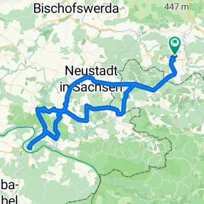
Bahnradweg Cunewalde
A cycling route starting in Schirgiswalde, Saxony, Germany.
Overview
About this route
Bahnstrecke wird zur Radstrecke - Jan. 2014: noch nicht ganz fertig - aber schon fahrbar
- -:--
- Duration
- 51.3 km
- Distance
- 375 m
- Ascent
- 367 m
- Descent
- ---
- Avg. speed
- ---
- Avg. speed
Route quality
Waytypes & surfaces along the route
Waytypes
Busy road
19.8 km
(39 %)
Quiet road
19.4 km
(38 %)
Surfaces
Paved
31 km
(60 %)
Unpaved
0.1 km
(<1 %)
Asphalt
30.7 km
(60 %)
Concrete
0.2 km
(<1 %)
Continue with Bikemap
Use, edit, or download this cycling route
You would like to ride Bahnradweg Cunewalde or customize it for your own trip? Here is what you can do with this Bikemap route:
Free features
- Save this route as favorite or in collections
- Copy & plan your own version of this route
- Sync your route with Garmin or Wahoo
Premium features
Free trial for 3 days, or one-time payment. More about Bikemap Premium.
- Navigate this route on iOS & Android
- Export a GPX / KML file of this route
- Create your custom printout (try it for free)
- Download this route for offline navigation
Discover more Premium features.
Get Bikemap PremiumFrom our community
Other popular routes starting in Schirgiswalde
- Sohland Karlstal Zeidler
- Distance
- 19 km
- Ascent
- 298 m
- Descent
- 171 m
- Location
- Schirgiswalde, Saxony, Germany
- Sohland-Harrachov-Dvoracka-Rezek
- Distance
- 116.7 km
- Ascent
- 1,441 m
- Descent
- 859 m
- Location
- Schirgiswalde, Saxony, Germany
- kleine Tour um den Hohberg in Schirgiswalde
- Distance
- 4.8 km
- Ascent
- 128 m
- Descent
- 131 m
- Location
- Schirgiswalde, Saxony, Germany
- Mit dem Fahrrad von Schirgiswalde nach Bautzen
- Distance
- 17.1 km
- Ascent
- 146 m
- Descent
- 317 m
- Location
- Schirgiswalde, Saxony, Germany
- Schönbach b. Cunewalde
- Distance
- 57 km
- Ascent
- 583 m
- Descent
- 583 m
- Location
- Schirgiswalde, Saxony, Germany
- Zum Butterberg
- Distance
- 72.7 km
- Ascent
- 602 m
- Descent
- 602 m
- Location
- Schirgiswalde, Saxony, Germany
- Um den Valtenberg
- Distance
- 50.5 km
- Ascent
- 436 m
- Descent
- 436 m
- Location
- Schirgiswalde, Saxony, Germany
- Sport in Radeberg
- Distance
- 91.5 km
- Ascent
- 542 m
- Descent
- 542 m
- Location
- Schirgiswalde, Saxony, Germany
Open it in the app