

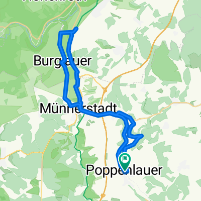
Wanderung Thundorf/Oberlauringen
A cycling route starting in Maßbach, Bavaria, Germany.
Overview
About this route
Hike to Beer Garden Oberlauringen
- -:--
- Duration
- 7.4 km
- Distance
- 71 m
- Ascent
- 68 m
- Descent
- ---
- Avg. speed
- ---
- Max. altitude
Route quality
Waytypes & surfaces along the route
Waytypes
Road
2.9 km
(39 %)
Quiet road
2.7 km
(37 %)
Surfaces
Paved
3.3 km
(45 %)
Asphalt
3.2 km
(43 %)
Paved (undefined)
0.1 km
(2 %)
Undefined
4.1 km
(55 %)
Continue with Bikemap
Use, edit, or download this cycling route
You would like to ride Wanderung Thundorf/Oberlauringen or customize it for your own trip? Here is what you can do with this Bikemap route:
Free features
- Save this route as favorite or in collections
- Copy & plan your own version of this route
- Sync your route with Garmin or Wahoo
Premium features
Free trial for 3 days, or one-time payment. More about Bikemap Premium.
- Navigate this route on iOS & Android
- Export a GPX / KML file of this route
- Create your custom printout (try it for free)
- Download this route for offline navigation
Discover more Premium features.
Get Bikemap PremiumFrom our community
Other popular routes starting in Maßbach
 Poppenlauer-Salz
- Distance
- 32.7 km
- Ascent
- 0 m
- Descent
- 0 m
- Location
- Maßbach, Bavaria, Germany
 Maßbach 50 km
- Distance
- 56.4 km
- Ascent
- 802 m
- Descent
- 802 m
- Location
- Maßbach, Bavaria, Germany
 LauertalMühlenRadwegKurz
- Distance
- 15.4 km
- Ascent
- 98 m
- Descent
- 33 m
- Location
- Maßbach, Bavaria, Germany
 PPL-MDHSN-MBCH-BHSN-PPL 42,6km
- Distance
- 42.6 km
- Ascent
- 254 m
- Descent
- 255 m
- Location
- Maßbach, Bavaria, Germany
 Wanderung Rothausen/Oberlauringen
- Distance
- 11.4 km
- Ascent
- 72 m
- Descent
- 31 m
- Location
- Maßbach, Bavaria, Germany
 PPL-BGL-PPL 20,5km
- Distance
- 20.5 km
- Ascent
- 117 m
- Descent
- 114 m
- Location
- Maßbach, Bavaria, Germany
 Tour de Lauertal VIII
- Distance
- 29.1 km
- Ascent
- 105 m
- Descent
- 105 m
- Location
- Maßbach, Bavaria, Germany
 Wanderung Thundorf/Oberlauringen
- Distance
- 7.4 km
- Ascent
- 71 m
- Descent
- 68 m
- Location
- Maßbach, Bavaria, Germany
Open it in the app