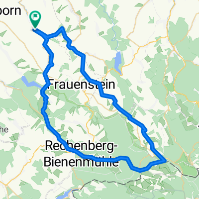
Wanderung+Rad
A cycling route starting in Lichtenberg, Saxony, Germany.
Overview
About this route
Für Wanderung und Rad geeignet
- -:--
- Duration
- 12.1 km
- Distance
- 126 m
- Ascent
- 126 m
- Descent
- ---
- Avg. speed
- ---
- Max. altitude
Route quality
Waytypes & surfaces along the route
Waytypes
Track
8 km
(66 %)
Quiet road
1.5 km
(12 %)
Surfaces
Paved
5.2 km
(43 %)
Unpaved
6.4 km
(53 %)
Gravel
3.9 km
(32 %)
Asphalt
3.6 km
(30 %)
Continue with Bikemap
Use, edit, or download this cycling route
You would like to ride Wanderung+Rad or customize it for your own trip? Here is what you can do with this Bikemap route:
Free features
- Save this route as favorite or in collections
- Copy & plan your own version of this route
- Sync your route with Garmin or Wahoo
Premium features
Free trial for 3 days, or one-time payment. More about Bikemap Premium.
- Navigate this route on iOS & Android
- Export a GPX / KML file of this route
- Create your custom printout (try it for free)
- Download this route for offline navigation
Discover more Premium features.
Get Bikemap PremiumFrom our community
Other popular routes starting in Lichtenberg
Route um Bobritzsch-Hilbersdorf- Distance
- 31.2 km
- Ascent
- 244 m
- Descent
- 247 m
- Location
- Lichtenberg, Saxony, Germany
Nove Mesto.gpx- Distance
- 79.6 km
- Ascent
- 597 m
- Descent
- 595 m
- Location
- Lichtenberg, Saxony, Germany
ET2014_1. Etappe- Distance
- 29.7 km
- Ascent
- 367 m
- Descent
- 414 m
- Location
- Lichtenberg, Saxony, Germany
Bäche - Teiche - Mühlen- Distance
- 45.5 km
- Ascent
- 506 m
- Descent
- 460 m
- Location
- Lichtenberg, Saxony, Germany
Bobritzsch, Burkersdorf Talsperre, Walkmühle Frauenstein, Burkersdorf, Bobritzsch- Distance
- 28.3 km
- Ascent
- 434 m
- Descent
- 433 m
- Location
- Lichtenberg, Saxony, Germany
EZF Lichtenberg (Erzgebirge)- Distance
- 14.6 km
- Ascent
- 147 m
- Descent
- 264 m
- Location
- Lichtenberg, Saxony, Germany
Knödelrunde.gpx- Distance
- 74.9 km
- Ascent
- 683 m
- Descent
- 684 m
- Location
- Lichtenberg, Saxony, Germany
1. Flachetappe und Eröffnung ERZ-Tour 2014- Distance
- 52.7 km
- Ascent
- 488 m
- Descent
- 536 m
- Location
- Lichtenberg, Saxony, Germany
Open it in the app

