

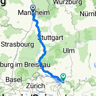
ADFC Mannheim So,12.07.2009
A cycling route starting in Ludwigshafen am Rhein, Rhineland-Palatinate, Germany.
Overview
About this route
- -:--
- Duration
- 87.7 km
- Distance
- 326 m
- Ascent
- 323 m
- Descent
- ---
- Avg. speed
- 245 m
- Max. altitude
Route quality
Waytypes & surfaces along the route
Waytypes
Track
21 km
(24 %)
Path
21 km
(24 %)
Surfaces
Paved
65.8 km
(75 %)
Unpaved
7.9 km
(9 %)
Asphalt
61.4 km
(70 %)
Gravel
6.1 km
(7 %)
Continue with Bikemap
Use, edit, or download this cycling route
You would like to ride ADFC Mannheim So,12.07.2009 or customize it for your own trip? Here is what you can do with this Bikemap route:
Free features
- Save this route as favorite or in collections
- Copy & plan your own version of this route
- Split it into stages to create a multi-day tour
- Sync your route with Garmin or Wahoo
Premium features
Free trial for 3 days, or one-time payment. More about Bikemap Premium.
- Navigate this route on iOS & Android
- Export a GPX / KML file of this route
- Create your custom printout (try it for free)
- Download this route for offline navigation
Discover more Premium features.
Get Bikemap PremiumFrom our community
Other popular routes starting in Ludwigshafen am Rhein
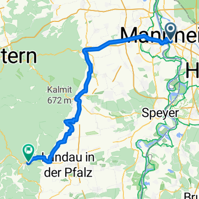
 LU-Kalmit-LU
- Distance
- 97.5 km
- Ascent
- 688 m
- Descent
- 694 m
- Location
- Ludwigshafen am Rhein, Rhineland-Palatinate, Germany
 BASF Radtour 2011
- Distance
- 159.1 km
- Ascent
- 667 m
- Descent
- 668 m
- Location
- Ludwigshafen am Rhein, Rhineland-Palatinate, Germany
 ¿?· ? nach ¿?· ?
- Distance
- 23.1 km
- Ascent
- 39 m
- Descent
- 49 m
- Location
- Ludwigshafen am Rhein, Rhineland-Palatinate, Germany
 09-08-29 17.RBF-1.Etappe: Mannheim-Heidelberg-Mannheim
- Distance
- 59.6 km
- Ascent
- 290 m
- Descent
- 284 m
- Location
- Ludwigshafen am Rhein, Rhineland-Palatinate, Germany
 Ludwigshafen am Rhein - Mainz
- Distance
- 354.4 km
- Ascent
- 3,557 m
- Descent
- 3,250 m
- Location
- Ludwigshafen am Rhein, Rhineland-Palatinate, Germany
 MA - Speyer
- Distance
- 55.5 km
- Ascent
- 71 m
- Descent
- 71 m
- Location
- Ludwigshafen am Rhein, Rhineland-Palatinate, Germany
 Ludwigshafen am Rhein - Annweiler am Trifels
- Distance
- 72.8 km
- Ascent
- 149 m
- Descent
- 67 m
- Location
- Ludwigshafen am Rhein, Rhineland-Palatinate, Germany
 ADFC Mannheim So,12.07.2009
- Distance
- 87.7 km
- Ascent
- 326 m
- Descent
- 323 m
- Location
- Ludwigshafen am Rhein, Rhineland-Palatinate, Germany
Open it in the app