1 VALIDA XCM "LADERAS DE EL CORAZON" 6 K MENORES MACHACHI 2014
A cycling route starting in Machachi, Provincia de Pichincha, Ecuador.
Overview
About this route
INFANTILES Y PRE INFANTILES
- -:--
- Duration
- 5.8 km
- Distance
- 106 m
- Ascent
- 108 m
- Descent
- ---
- Avg. speed
- ---
- Avg. speed
Route quality
Waytypes & surfaces along the route
Waytypes
Quiet road
5.4 km
(94 %)
Access road
0.3 km
(6 %)
Undefined
0 km
(<1 %)
Surfaces
Unpaved
5 km
(87 %)
Unpaved (undefined)
5 km
(87 %)
Undefined
0.7 km
(13 %)
Continue with Bikemap
Use, edit, or download this cycling route
You would like to ride 1 VALIDA XCM "LADERAS DE EL CORAZON" 6 K MENORES MACHACHI 2014 or customize it for your own trip? Here is what you can do with this Bikemap route:
Free features
- Save this route as favorite or in collections
- Copy & plan your own version of this route
- Sync your route with Garmin or Wahoo
Premium features
Free trial for 3 days, or one-time payment. More about Bikemap Premium.
- Navigate this route on iOS & Android
- Export a GPX / KML file of this route
- Create your custom printout (try it for free)
- Download this route for offline navigation
Discover more Premium features.
Get Bikemap PremiumFrom our community
Other popular routes starting in Machachi
- MTB - Ilinizas
- Distance
- 41.3 km
- Ascent
- 586 m
- Descent
- 722 m
- Location
- Machachi, Provincia de Pichincha, Ecuador
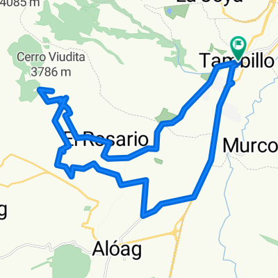
- De Carretera Panamericana, Machachi a Troncal de la Sierra
- Distance
- 14.7 km
- Ascent
- 538 m
- Descent
- 37 m
- Location
- Machachi, Provincia de Pichincha, Ecuador
- Tour Montaña Nestlé Papagayo 80k
- Distance
- 75.5 km
- Ascent
- 1,298 m
- Descent
- 1,298 m
- Location
- Machachi, Provincia de Pichincha, Ecuador
- CARRERA SIERRALOMA 2010 SEGUNDO DIA
- Distance
- 29 km
- Ascent
- 926 m
- Descent
- 926 m
- Location
- Machachi, Provincia de Pichincha, Ecuador
- Tour Montaña Svelty en Papagayo 20k
- Distance
- 19.4 km
- Ascent
- 292 m
- Descent
- 292 m
- Location
- Machachi, Provincia de Pichincha, Ecuador
- RUTA DEL TREN. Machachi - El Boliche. 18 Septiembre 2011. CLONED FROM ROUTE 1250152
- Distance
- 24.7 km
- Ascent
- 694 m
- Descent
- 55 m
- Location
- Machachi, Provincia de Pichincha, Ecuador
- Tour Montaña El Chaupi Día 1
- Distance
- 41.1 km
- Ascent
- 820 m
- Descent
- 820 m
- Location
- Machachi, Provincia de Pichincha, Ecuador
- Aloasi-3 Marías- Chaupi- Aloasi
- Distance
- 40.2 km
- Ascent
- 639 m
- Descent
- 634 m
- Location
- Machachi, Provincia de Pichincha, Ecuador
Open it in the app