

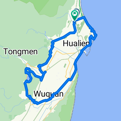
Actual DAY 09r: Hualien to Taidong, 168km
A cycling route starting in Hualien City, Taiwan, Taiwan.
Overview
About this route
Actual: Instead of the planned route, the AMS got to rethink about continuing but at Taichung's Grano House, the boss encouraged me to take the Taichung Express to Hualien and then ride Hualien to Taidong.
So I had my bike bagged at Grano House, get all the help I can from Mr Yu and Zoe so that I can catch a taxi early morning to arrive at Taichung Train Station to catch the 5:56am Express. All went according to this revised plan and the journey was indeed a new experience for this 50+you flatland Singaporean. This proved to be the longest day - cycling from Hualien to Taidong, catching the 8pm Express to Kaoshiung, search for a hotel (Kindess at 1700NT) and resting at 2am after laundry. VERY SURPRISINGLY, I did not really feel exhausted after the 168km. I guess the full impact of altitude 'training' was evident here. This is confirmed by Mr Liu, a TCM businessman who sat next to me saying that I don't look tired at all. Revised: Can try to do this 240km to end at Checheng, take a Taxi to Kaoshiung - Zouying Station. Rest for the night and go visit Velocite the next day and spend time in Kaoshiung before taking the HSR back to Taipei. <span style="color: rgb(102, 102, 102); font-family: Helvetica, 'Helvetica Neue', Arial, sans-serif; line-height: 20px; ">Getting closer ... but perhaps hang around at Taitung City for Brunch, load up before setting off. Will consider resting at Taitung County Daren Township if there is any B&Bs. </span>- -:--
- Duration
- 168.3 km
- Distance
- 648 m
- Ascent
- 619 m
- Descent
- ---
- Avg. speed
- ---
- Max. altitude

Route quality
Waytypes & surfaces along the route
Waytypes
Quiet road
15.1 km
(9 %)
Access road
5 km
(3 %)
Surfaces
Paved
15.1 km
(9 %)
Asphalt
11.8 km
(7 %)
Paved (undefined)
3.4 km
(2 %)
Undefined
153.1 km
(91 %)
Route highlights
Points of interest along the route
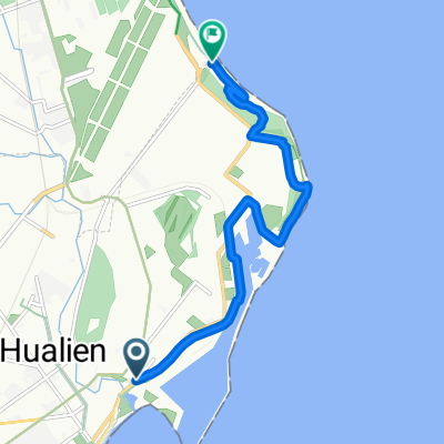
Point of interest after 168.3 km
VELOCITE BIKE SHOP
Continue with Bikemap
Use, edit, or download this cycling route
You would like to ride Actual DAY 09r: Hualien to Taidong, 168km or customize it for your own trip? Here is what you can do with this Bikemap route:
Free features
- Save this route as favorite or in collections
- Copy & plan your own version of this route
- Split it into stages to create a multi-day tour
- Sync your route with Garmin or Wahoo
Premium features
Free trial for 3 days, or one-time payment. More about Bikemap Premium.
- Navigate this route on iOS & Android
- Export a GPX / KML file of this route
- Create your custom printout (try it for free)
- Download this route for offline navigation
Discover more Premium features.
Get Bikemap PremiumFrom our community
Other popular routes starting in Hualien City
 樂虎LOVE 兩日東進武嶺(第一天)
- Distance
- 70.6 km
- Ascent
- 4,065 m
- Descent
- 1,722 m
- Location
- Hualien City, Taiwan, Taiwan
 20100417 環花東380超級挑戰隊 DAY1
- Distance
- 182.5 km
- Ascent
- 624 m
- Descent
- 596 m
- Location
- Hualien City, Taiwan, Taiwan
 20190302美崙溪和咖小鈞吃飯
- Distance
- 19.8 km
- Ascent
- 536 m
- Descent
- 532 m
- Location
- Hualien City, Taiwan, Taiwan
 中橫之旅
中橫之旅- Distance
- 136.2 km
- Ascent
- 4,056 m
- Descent
- 3,646 m
- Location
- Hualien City, Taiwan, Taiwan
 Hualien to Taitung
- Distance
- 193.6 km
- Ascent
- 648 m
- Descent
- 630 m
- Location
- Hualien City, Taiwan, Taiwan
 Hualien Two Lakes HOOF edit
- Distance
- 67.4 km
- Ascent
- 697 m
- Descent
- 670 m
- Location
- Hualien City, Taiwan, Taiwan
 七星潭單車道
- Distance
- 9.7 km
- Ascent
- 44 m
- Descent
- 49 m
- Location
- Hualien City, Taiwan, Taiwan
 東爽第二日
東爽第二日- Distance
- 306.3 km
- Ascent
- 1,261 m
- Descent
- 1,233 m
- Location
- Hualien City, Taiwan, Taiwan
Open it in the app