

Dojazd do pracy
A cycling route starting in Tarnowiec, Lesser Poland Voivodeship, Poland.
Overview
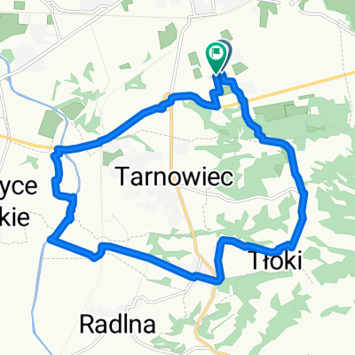
About this route
Alternative route from Zamenhofa Street to the combined heat and power plant
- -:--
- Duration
- 14.3 km
- Distance
- 51 m
- Ascent
- 71 m
- Descent
- ---
- Avg. speed
- ---
- Max. altitude
Route highlights
Points of interest along the route
Point of interest after 6.2 km
Bachówki - żelazny krzyż przydrożny
Point of interest after 8.7 km
Kapliczka Matki Boskiej Częstochowskiej
Continue with Bikemap
Use, edit, or download this cycling route
You would like to ride Dojazd do pracy or customize it for your own trip? Here is what you can do with this Bikemap route:
Free features
- Save this route as favorite or in collections
- Copy & plan your own version of this route
- Sync your route with Garmin or Wahoo
Premium features
Free trial for 3 days, or one-time payment. More about Bikemap Premium.
- Navigate this route on iOS & Android
- Export a GPX / KML file of this route
- Create your custom printout (try it for free)
- Download this route for offline navigation
Discover more Premium features.
Get Bikemap PremiumFrom our community
Other popular routes starting in Tarnowiec
 Tarnowiec do Tarnowiec
- Distance
- 85.8 km
- Ascent
- 211 m
- Descent
- 279 m
- Location
- Tarnowiec, Lesser Poland Voivodeship, Poland
 Przez Zawadę, nowodworze, do rzeki Białe, Biała w brod, do koszyc wielkich i spowrotem wzdłuż obwodnicy
- Distance
- 13.7 km
- Ascent
- 202 m
- Descent
- 203 m
- Location
- Tarnowiec, Lesser Poland Voivodeship, Poland
 Tarnowiec do Nowodworze
- Distance
- 95.9 km
- Ascent
- 531 m
- Descent
- 576 m
- Location
- Tarnowiec, Lesser Poland Voivodeship, Poland
 Tarnowiec do Tarnowiec
- Distance
- 49.2 km
- Ascent
- 188 m
- Descent
- 256 m
- Location
- Tarnowiec, Lesser Poland Voivodeship, Poland
 Tarnowiec do Tarnowiec
- Distance
- 125.7 km
- Ascent
- 1,040 m
- Descent
- 1,118 m
- Location
- Tarnowiec, Lesser Poland Voivodeship, Poland
 Tarnowiec do 42B
- Distance
- 33.4 km
- Ascent
- 177 m
- Descent
- 252 m
- Location
- Tarnowiec, Lesser Poland Voivodeship, Poland
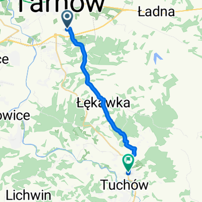 Szlakiem św. Jakuba z Tarnowa do Tuchowa
- Distance
- 13.3 km
- Ascent
- 267 m
- Descent
- 253 m
- Location
- Tarnowiec, Lesser Poland Voivodeship, Poland
 Tarnowiec do Tarnowiec
- Distance
- 149.6 km
- Ascent
- 465 m
- Descent
- 536 m
- Location
- Tarnowiec, Lesser Poland Voivodeship, Poland
Open it in the app