

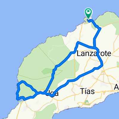
Conil Trip - Distance 50km
A cycling route starting in Tinajo, Canary Islands, Spain.
Overview
About this route
Level: Intermediate Total climbing: 380m
You go via Tinajo and La Vagueta to Conil and go through a small part of the biggest wine district on the island, La Geria before you enter the wine district El Grifo. Homewards via La Florida, Tiagua and Soo(cloned from route 2419635)
- -:--
- Duration
- 52.2 km
- Distance
- 415 m
- Ascent
- 415 m
- Descent
- ---
- Avg. speed
- ---
- Max. altitude

Route quality
Waytypes & surfaces along the route
Waytypes
Quiet road
9.9 km
(19 %)
Road
7.3 km
(14 %)
Surfaces
Paved
38.1 km
(73 %)
Unpaved
2.6 km
(5 %)
Asphalt
36 km
(69 %)
Paved (undefined)
2.1 km
(4 %)
Continue with Bikemap
Use, edit, or download this cycling route
You would like to ride Conil Trip - Distance 50km or customize it for your own trip? Here is what you can do with this Bikemap route:
Free features
- Save this route as favorite or in collections
- Copy & plan your own version of this route
- Sync your route with Garmin or Wahoo
Premium features
Free trial for 3 days, or one-time payment. More about Bikemap Premium.
- Navigate this route on iOS & Android
- Export a GPX / KML file of this route
- Create your custom printout (try it for free)
- Download this route for offline navigation
Discover more Premium features.
Get Bikemap PremiumFrom our community
Other popular routes starting in Tinajo
 Conil Trip - Distance 50km
- Distance
- 52.2 km
- Ascent
- 415 m
- Descent
- 415 m
- Location
- Tinajo, Canary Islands, Spain
 Mirador del Rio 112k
- Distance
- 111.7 km
- Ascent
- 1,739 m
- Descent
- 1,739 m
- Location
- Tinajo, Canary Islands, Spain
 Feuer lang 59
- Distance
- 59.7 km
- Ascent
- 879 m
- Descent
- 880 m
- Location
- Tinajo, Canary Islands, Spain
 Tabayesco 85km
- Distance
- 85.2 km
- Ascent
- 1,381 m
- Descent
- 1,383 m
- Location
- Tinajo, Canary Islands, Spain
 La Santa to El Golfo
- Distance
- 84 km
- Ascent
- 765 m
- Descent
- 764 m
- Location
- Tinajo, Canary Islands, Spain
 Krater – Blick in den Krater Runde von Tinajo
- Distance
- 11.4 km
- Ascent
- 405 m
- Descent
- 405 m
- Location
- Tinajo, Canary Islands, Spain
 Tinajo-Haria-Orzola-CostaTeguise
- Distance
- 101.3 km
- Ascent
- 0 m
- Descent
- 0 m
- Location
- Tinajo, Canary Islands, Spain
 Kanári szigetek 3. nap
- Distance
- 103 km
- Ascent
- 926 m
- Descent
- 912 m
- Location
- Tinajo, Canary Islands, Spain
Open it in the app