
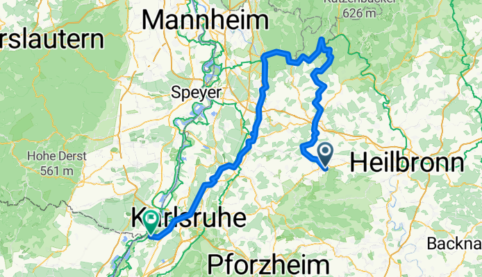
von Eppingen zum Neckar durch Heidelberg nach Karlsruhe
A cycling route starting in Eppingen, Baden-Wurttemberg, Germany.
Overview
About this route
<ul>
<li>a route of the RadSportSenioren Rheinstetten</li>
<li>currently in progress</li>
</ul>
Translated, show original (German)- -:--
- Duration
- 151 km
- Distance
- 569 m
- Ascent
- 654 m
- Descent
- ---
- Avg. speed
- ---
- Max. altitude

Continue with Bikemap
Use, edit, or download this cycling route
You would like to ride von Eppingen zum Neckar durch Heidelberg nach Karlsruhe or customize it for your own trip? Here is what you can do with this Bikemap route:
Free features
- Save this route as favorite or in collections
- Copy & plan your own version of this route
- Split it into stages to create a multi-day tour
- Sync your route with Garmin or Wahoo
Premium features
Free trial for 3 days, or one-time payment. More about Bikemap Premium.
- Navigate this route on iOS & Android
- Export a GPX / KML file of this route
- Create your custom printout (try it for free)
- Download this route for offline navigation
Discover more Premium features.
Get Bikemap PremiumFrom our community
Other popular routes starting in Eppingen
 von Eppingen zum Neckar durch Heidelberg nach Karlsruhe
- Distance
- 151 km
- Ascent
- 569 m
- Descent
- 654 m
- Location
- Eppingen, Baden-Wurttemberg, Germany
 Kraichgau - Blick Tour
- Distance
- 44 km
- Ascent
- 419 m
- Descent
- 421 m
- Location
- Eppingen, Baden-Wurttemberg, Germany
 Eppingen Mühlbacher Straße nach Kasteneckstraße
- Distance
- 48.2 km
- Ascent
- 674 m
- Descent
- 616 m
- Location
- Eppingen, Baden-Wurttemberg, Germany
 Tour de Stromberg
- Distance
- 63.1 km
- Ascent
- 837 m
- Descent
- 751 m
- Location
- Eppingen, Baden-Wurttemberg, Germany
 einfach..
- Distance
- 28.4 km
- Ascent
- 83 m
- Descent
- 123 m
- Location
- Eppingen, Baden-Wurttemberg, Germany
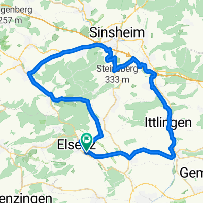
 Elsenz-Eppingen
- Distance
- 21.1 km
- Ascent
- 110 m
- Descent
- 110 m
- Location
- Eppingen, Baden-Wurttemberg, Germany
 Aktiv-Tour im Kraichgau-Stromberg
- Distance
- 44.6 km
- Ascent
- 410 m
- Descent
- 410 m
- Location
- Eppingen, Baden-Wurttemberg, Germany
 41 km Elsenz-Dühren-Angelbachtal
- Distance
- 41.8 km
- Ascent
- 282 m
- Descent
- 267 m
- Location
- Eppingen, Baden-Wurttemberg, Germany
Open it in the app