

010 - 2014
A cycling route starting in Stia, Tuscany, Italy.
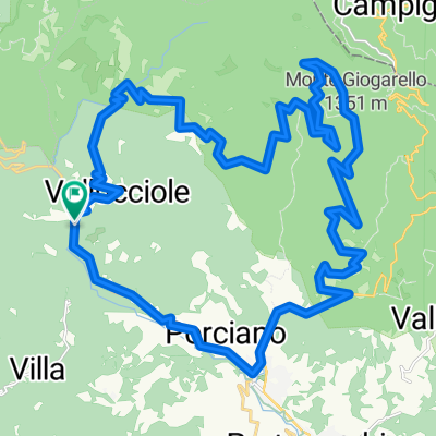
Overview
About this route
10 dzień wyprawy rowerowej Italia & Alpy 2014
Consuma - San Giovanni Alla Vena/ 112 km- -:--
- Duration
- 111.2 km
- Distance
- 326 m
- Ascent
- 1,062 m
- Descent
- ---
- Avg. speed
- ---
- Max. altitude

Route quality
Waytypes & surfaces along the route
Waytypes
Quiet road
21.1 km
(19 %)
Road
5.6 km
(5 %)
Surfaces
Paved
72.3 km
(65 %)
Asphalt
72.3 km
(65 %)
Undefined
38.9 km
(35 %)
Route highlights
Points of interest along the route

Point of interest after 111.2 km
Na dziko w San Giovanni Alla Vena
Continue with Bikemap
Use, edit, or download this cycling route
You would like to ride 010 - 2014 or customize it for your own trip? Here is what you can do with this Bikemap route:
Free features
- Save this route as favorite or in collections
- Copy & plan your own version of this route
- Split it into stages to create a multi-day tour
- Sync your route with Garmin or Wahoo
Premium features
Free trial for 3 days, or one-time payment. More about Bikemap Premium.
- Navigate this route on iOS & Android
- Export a GPX / KML file of this route
- Create your custom printout (try it for free)
- Download this route for offline navigation
Discover more Premium features.
Get Bikemap PremiumFrom our community
Other popular routes starting in Stia
 Stia - Castello di Romena - Stia
- Distance
- 9 km
- Ascent
- 293 m
- Descent
- 293 m
- Location
- Stia, Tuscany, Italy
 Anello di Camaldoli da Stia
- Distance
- 37.3 km
- Ascent
- 1,008 m
- Descent
- 1,005 m
- Location
- Stia, Tuscany, Italy
 Camaldoli 1
- Distance
- 49.5 km
- Ascent
- 1,327 m
- Descent
- 1,320 m
- Location
- Stia, Tuscany, Italy
 PFNC 1
- Distance
- 31.8 km
- Ascent
- 1,100 m
- Descent
- 1,057 m
- Location
- Stia, Tuscany, Italy
 FORESTA OFF ROAD
- Distance
- 38.8 km
- Ascent
- 1,176 m
- Descent
- 1,096 m
- Location
- Stia, Tuscany, Italy
 Pratovecchio Pian del Papa-Passo della Calla-Eremo di Camaldoli-Pian del Papa
- Distance
- 57.6 km
- Ascent
- 1,537 m
- Descent
- 1,531 m
- Location
- Stia, Tuscany, Italy
 Molin di Bucchio anello
- Distance
- 38.3 km
- Ascent
- 1,149 m
- Descent
- 1,153 m
- Location
- Stia, Tuscany, Italy
 Da Stia all’eremo di Camaldoli via Asqua e per la via dei legni o via dei tedeschi
- Distance
- 48.8 km
- Ascent
- 1,754 m
- Descent
- 1,757 m
- Location
- Stia, Tuscany, Italy
Open it in the app