

Vom Kammel- ins Wertachtal und zurück
A cycling route starting in Aletshausen, Bavaria, Germany.
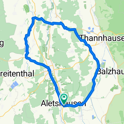
Overview
About this route
From Aletshausen towards Allgäu. All small paved roads and bike paths except for about 500-700m between Oberauerbach and Stetten where there's a small gravel section (I was too lazy to correct that part). Otherwise, the motto applies: 'No avoiding climbs!!'. From Schlingen (the southeasternmost point), the route is no longer optimized for small roads because it started raining and I wanted to get home as quickly as possible.
- -:--
- Duration
- 106.5 km
- Distance
- 729 m
- Ascent
- 696 m
- Descent
- ---
- Avg. speed
- 727 m
- Max. altitude
Route quality
Waytypes & surfaces along the route
Waytypes
Quiet road
55.4 km
(52 %)
Road
26.6 km
(25 %)
Surfaces
Paved
58.6 km
(55 %)
Asphalt
46.8 km
(44 %)
Paved (undefined)
11.7 km
(11 %)
Undefined
47.9 km
(45 %)
Continue with Bikemap
Use, edit, or download this cycling route
You would like to ride Vom Kammel- ins Wertachtal und zurück or customize it for your own trip? Here is what you can do with this Bikemap route:
Free features
- Save this route as favorite or in collections
- Copy & plan your own version of this route
- Split it into stages to create a multi-day tour
- Sync your route with Garmin or Wahoo
Premium features
Free trial for 3 days, or one-time payment. More about Bikemap Premium.
- Navigate this route on iOS & Android
- Export a GPX / KML file of this route
- Create your custom printout (try it for free)
- Download this route for offline navigation
Discover more Premium features.
Get Bikemap PremiumFrom our community
Other popular routes starting in Aletshausen
 Mindelheim
- Distance
- 54.4 km
- Ascent
- 273 m
- Descent
- 276 m
- Location
- Aletshausen, Bavaria, Germany
 Aletshausen nach Ettringen
- Distance
- 27.9 km
- Ascent
- 417 m
- Descent
- 363 m
- Location
- Aletshausen, Bavaria, Germany
 Von Aletshausen in die westlichen Wälder
- Distance
- 113.7 km
- Ascent
- 1,001 m
- Descent
- 998 m
- Location
- Aletshausen, Bavaria, Germany
 Radrunde durch Aletshausen
- Distance
- 16.4 km
- Ascent
- 173 m
- Descent
- 175 m
- Location
- Aletshausen, Bavaria, Germany
 Lange Ausfahrt vom 10.07.16, 18:10
- Distance
- 32.5 km
- Ascent
- 96 m
- Descent
- 99 m
- Location
- Aletshausen, Bavaria, Germany
 Runde Nord
- Distance
- 39.9 km
- Ascent
- 333 m
- Descent
- 331 m
- Location
- Aletshausen, Bavaria, Germany
 Aletshausen 4 Täler (Kammel,Günz, Roth Mindel
- Distance
- 79.8 km
- Ascent
- 545 m
- Descent
- 525 m
- Location
- Aletshausen, Bavaria, Germany
 Vom Kammel- ins Wertachtal und zurück
- Distance
- 106.5 km
- Ascent
- 729 m
- Descent
- 696 m
- Location
- Aletshausen, Bavaria, Germany
Open it in the app