

Font Roja
A cycling route starting in Ontinyent, Valencia, Spain.
Overview
About this route
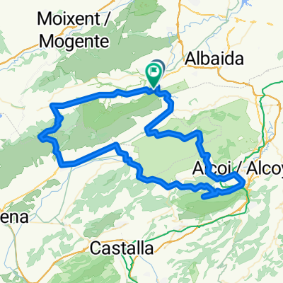
Ontinyent-Mariola-Font Roja-Mont Bigot-Fontanars
- -:--
- Duration
- 102.9 km
- Distance
- 1,511 m
- Ascent
- 1,519 m
- Descent
- ---
- Avg. speed
- ---
- Max. altitude

Route quality
Waytypes & surfaces along the route
Waytypes
Road
55.6 km
(54 %)
Quiet road
10.3 km
(10 %)
Surfaces
Paved
27.8 km
(27 %)
Unpaved
4.1 km
(4 %)
Asphalt
27.8 km
(27 %)
Gravel
3.1 km
(3 %)
Continue with Bikemap
Use, edit, or download this cycling route
You would like to ride Font Roja or customize it for your own trip? Here is what you can do with this Bikemap route:
Free features
- Save this route as favorite or in collections
- Copy & plan your own version of this route
- Split it into stages to create a multi-day tour
- Sync your route with Garmin or Wahoo
Premium features
Free trial for 3 days, or one-time payment. More about Bikemap Premium.
- Navigate this route on iOS & Android
- Export a GPX / KML file of this route
- Create your custom printout (try it for free)
- Download this route for offline navigation
Discover more Premium features.
Get Bikemap PremiumFrom our community
Other popular routes starting in Ontinyent
 Moixent-Achter
- Distance
- 52.9 km
- Ascent
- 885 m
- Descent
- 896 m
- Location
- Ontinyent, Valencia, Spain
 Ontinyent - Agres - Neveras - Ontinyent
- Distance
- 42.1 km
- Ascent
- 1,025 m
- Descent
- 1,064 m
- Location
- Ontinyent, Valencia, Spain
 Font Roja
- Distance
- 102.9 km
- Ascent
- 1,511 m
- Descent
- 1,519 m
- Location
- Ontinyent, Valencia, Spain
 Font Roja 2
- Distance
- 106.6 km
- Ascent
- 1,492 m
- Descent
- 1,479 m
- Location
- Ontinyent, Valencia, Spain
 Ontinyent - Aielo - Vallada - Moixent - Ontinyent
- Distance
- 49.8 km
- Ascent
- 1,010 m
- Descent
- 1,003 m
- Location
- Ontinyent, Valencia, Spain
 Vuelta a El Moro (Beneixama - Fontanars )
- Distance
- 59.5 km
- Ascent
- 837 m
- Descent
- 841 m
- Location
- Ontinyent, Valencia, Spain
 Torrater (por senda Enginyers) y Pla de Ponce (por Bocairent)
- Distance
- 56.3 km
- Ascent
- 747 m
- Descent
- 787 m
- Location
- Ontinyent, Valencia, Spain
 Ontinyent - L'Orxa - Daimus
- Distance
- 73.6 km
- Ascent
- 840 m
- Descent
- 1,200 m
- Location
- Ontinyent, Valencia, Spain
Open it in the app