Wanderung Märkische Schweiz
- 16.9 km
- 188 m
- 214 m
- Müncheberg, Brandenburg, Germany
A cycling route starting in Müncheberg, Brandenburg, Germany.
Overview
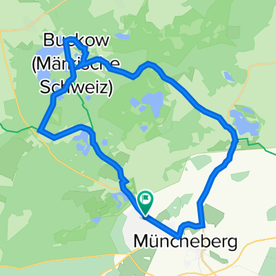
From Müncheberg station, accessible by regional train from Lichtenberg, head towards Dahmsdorf on cobblestones. However, it’s less than 500 m. Before climbing the hills, turn left towards Waldsieversdorf and follow the well-developed cycle path along the light railway to Buckow. Then, ride straight through Buckow, and at the town’s exit, a small challenge awaits with the switchbacks. Afterwards, continue towards Strausberg. At the Bollersdorf roundabout, take the L35 towards Prötzel. In Prötzel, continue towards Wriezen with constant ups and downs. Ride through Wriezen towards Bad Freienwalde. From there head towards Berlin, where the next challenge awaits: a roughly 3 km climb with a maximum gradient of 5%. After the climb, take the first left back towards Prötzel. Here too there are ups and downs. The road surface isn’t always the best, but it is manageable with a road bike. In Prötzel continue on to Strausberg. Those who wish can end the tour here and return to Berlin by S-Bahn or regional train. Otherwise, follow along the airfield or industrial area and at the roundabout (Audi dealership) return towards Müncheberg. Here, the ups and downs continue. In Müncheberg, board the regional train back to Lichtenberg.
I really enjoy this tour. Well-developed cycle paths, quiet country roads, and some moderately busy rural roads offer a balanced variety. The tour can easily be extended or shortened without major difficulties. Have fun cycling!
created this 16 years ago
Route quality
Path
10.1 km
(11 %)
Road
9.2 km
(10 %)
Paved
74.5 km
(81 %)
Unpaved
1.8 km
(2 %)
Asphalt
73.6 km
(80 %)
Paved (undefined)
0.9 km
(1 %)
Continue with Bikemap
You would like to ride Märkiches Hügelland or customize it for your own trip? Here is what you can do with this Bikemap route:
Free trial for 3 days, or one-time payment. More about Bikemap Premium.
Discover more Premium features.
Get Bikemap PremiumFrom our community
Open it in the app