

11 Okolo a cez Galmus
A cycling route starting in Krompachy, Košice Region, Slovakia.
Overview
About this route
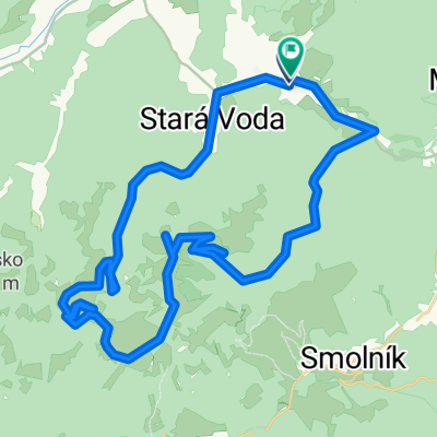
The route offers a pleasant bike ride in a natural environment. It passes through the landscape and scientifically significant area of Galmus, with the natural reserves of Červené skaly and Galmuská tisina. Our cycling journey begins in the center of Krompach at the town hall from the information and orientation spot. At the beginning we face 5 kilometers of gentle ascent along the main road on the green bicycle route 5855. After completing them, at the beginning of Sloviniek at the intersection near the cemetery, we turn right and continue a comfortable ride down the valley of Poráčsky brook to the Čierny bocian lodge. From there, the road surface changes to a solid one and we gain a significant amount of altitude. Meanwhile, we pass through a section lined with the protected natural area Červené skaly. From the Relaxsport center Poráč Park, we continue on the gravel road with a steep ascent up to Poráč. At the first intersection we turn right and continue on the blue bicycle route (2709) with a gentler ascent to the forest above the village. We then enjoy the 'swing-like' profile of the bike route until the junction of hiking and cycling paths of Galmus. Here we change from the blue bike route to the yellow one. We turn left and begin to descend along the forest road. The loss of altitude signals to us that the recreational center Za horou is not far away. At the intersection of hiking and cycling paths Za horou we turn right and continue on the shared section of the yellow and red bike route (014 Spišska bike route) to the junction of the Kondratka bike routes, where we turn again to the right onto the forest road and allow ourselves to be guided solely by the yellow bike route. We pass under the underpass of the railway line and the bridge over the Hornád. From the local road in Kolinovciach, we turn right onto the main road (end of cycling tourism signage), where a few unpleasant kilometers with dense traffic await us. In Krompach, at the main intersection, we turn right and take the local road on Hlavná street to reach the destination of our cycling loop.
- -:--
- Duration
- 33.8 km
- Distance
- 576 m
- Ascent
- 578 m
- Descent
- ---
- Avg. speed
- ---
- Max. altitude
Route quality
Waytypes & surfaces along the route
Waytypes
Track
22 km
(65 %)
Road
4.1 km
(12 %)
Surfaces
Paved
2.7 km
(8 %)
Unpaved
17.6 km
(52 %)
Unpaved (undefined)
11.2 km
(33 %)
Gravel
5.1 km
(15 %)
Continue with Bikemap
Use, edit, or download this cycling route
You would like to ride 11 Okolo a cez Galmus or customize it for your own trip? Here is what you can do with this Bikemap route:
Free features
- Save this route as favorite or in collections
- Copy & plan your own version of this route
- Sync your route with Garmin or Wahoo
Premium features
Free trial for 3 days, or one-time payment. More about Bikemap Premium.
- Navigate this route on iOS & Android
- Export a GPX / KML file of this route
- Create your custom printout (try it for free)
- Download this route for offline navigation
Discover more Premium features.
Get Bikemap PremiumFrom our community
Other popular routes starting in Krompachy
 PO HREBENI
- Distance
- 24.9 km
- Ascent
- 481 m
- Descent
- 712 m
- Location
- Krompachy, Košice Region, Slovakia
 Švedlár Zlatý stôl kanal Švedlár
- Distance
- 46.9 km
- Ascent
- 1,049 m
- Descent
- 1,051 m
- Location
- Krompachy, Košice Region, Slovakia
 2016_Wien_Lwiw_Tag03_202km_2.500hm
- Distance
- 201.4 km
- Ascent
- 1,439 m
- Descent
- 1,370 m
- Location
- Krompachy, Košice Region, Slovakia
 Krompachy - Kosice
- Distance
- 48.6 km
- Ascent
- 547 m
- Descent
- 720 m
- Location
- Krompachy, Košice Region, Slovakia
 Plejsy priehyba-Žakarovce-Mária Huta
- Distance
- 7 km
- Ascent
- 62 m
- Descent
- 606 m
- Location
- Krompachy, Košice Region, Slovakia
 Spišských 333EXTREME
- Distance
- 329.5 km
- Ascent
- 3,653 m
- Descent
- 3,653 m
- Location
- Krompachy, Košice Region, Slovakia
 Around Knola
- Distance
- 84 km
- Ascent
- 1,613 m
- Descent
- 1,601 m
- Location
- Krompachy, Košice Region, Slovakia
 Švedlar Genier Stara Voda strará štôlna Švedlar
- Distance
- 30.2 km
- Ascent
- 828 m
- Descent
- 766 m
- Location
- Krompachy, Košice Region, Slovakia
Open it in the app