
Plejsy priehyba-Žakarovce-Mária Huta
- 7 km
- 62 m
- 606 m
- Krompachy, Košice Region, Slovakia
A cycling route starting in Krompachy, Košice Region, Slovakia.
Overview
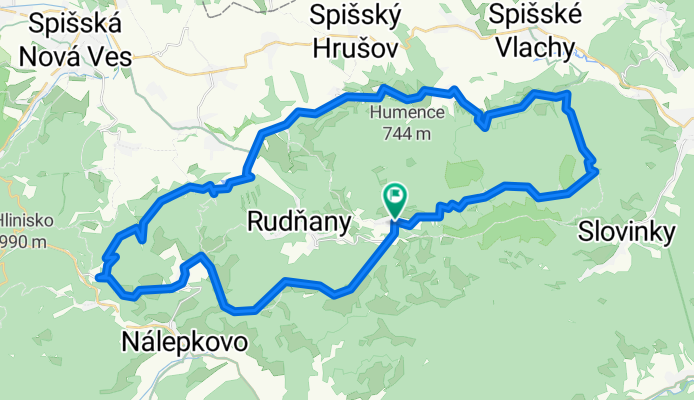
With a multitude of beautiful views, vast mountain meadows, forested and open landscapes, as well as valleys and preserved elements of an original village, this cycling route presents a great scenario of the Spiš region. It is a challenging cycling route. The route begins in the village of Poráč from the crossroads of cycle routes on green cycle route 5855 heading south. After a kilometer of comfortable cycling, we cross the state road. We continue on a rural unpaved road, which enters the forest after two hundred meters. The cycling signpost guides us with alternating gentle and steep climbs. At the hiking crossroads Pod Holým vrchom, an open landscape of forest meadows and pastures with many amazing views opens up before us, the most impressive being the panoramic view over the village of Závadka. The view of the Hornád basin in the background with the High Tatras, the Levoča Mountains, Branisko, and the Spiš castle is enchanting. After a short descent, we enter the mountain village of Závadka, with preserved original architecture and elements of original lifestyle characteristic of the Rusyn ethnicity. Two chapels around which the route runs are also interesting. As we leave the village, we can admire the natural monument Závadské skalky on the left. From the homonymous trail crossroads, we continue on the green cycle path 5855 through the always-open landscape with views. Three hundred meters past the Labková crossroads, we take a sharp right turn at a small trail intersection onto the state road and continue descending on the blue cycle route 2852 to Bindt. Along the route from Bindt to Oľa, there are many testimonies of the rich mining activity in the past. At the crossroads and trail intersections in Bindt, we turn right onto a macadam road. After a short descent, we continue comfortably through the Markuškovo Valley along the former mining narrow-gauge railway line. In the lower part of the valley on the left, we trace the edge of the tailings. After descending under the tailings, we pass through the former mining plant. We continue on the asphalt road always following the blue cycling sign, which ends at the site of the former settlement of Oľše at the cross under the lime tree (God's cross). From there, we continue on the red cycle route 014 of the Spiš cycling magistral down the valley of the Hornád river through the villages of Matejovce nad Hornádom, Chrasť nad Hornádom, Víťkovce to Olcnava. Along the way, the natural curiosity Sikľavá skala is particularly striking. From Olcnava, we head towards the northern slopes of Galmus, still being guided by the cycling sign of the Spiš cycling magistral. We pass recreation and rest areas such as Blatná and later Za horou. When reaching the crossroads of routes Za horou, we turn right and continue on a more than four-kilometre ascent on the yellow cycle route 8718 to the crossroads of routes Galmus. Here, we turn right, and the blue cycle route 2709 will lead us without difficulty back to Poráč.
created this 11 years ago
Route quality
Track
44.2 km
(80 %)
Road
6.1 km
(11 %)
Paved
5 km
(9 %)
Unpaved
40.3 km
(73 %)
Gravel
18.8 km
(34 %)
Unpaved (undefined)
18.2 km
(33 %)
Continue with Bikemap
You would like to ride 16 Za panoramatickými výhľadmi or customize it for your own trip? Here is what you can do with this Bikemap route:
Free trial for 3 days, or one-time payment. More about Bikemap Premium.
Discover more Premium features.
Get Bikemap PremiumFrom our community
Open it in the app