
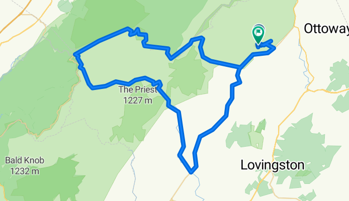
Paul Crabtree 94km
A cycling route starting in Nellysford, Virginia, United States.
Overview
About this route
Tracé Paul Drouin 94km
- -:--
- Duration
- 94.2 km
- Distance
- 1,150 m
- Ascent
- 1,151 m
- Descent
- ---
- Avg. speed
- ---
- Max. altitude
Route quality
Waytypes & surfaces along the route
Waytypes
Busy road
72.7 km
(77 %)
Quiet road
10.5 km
(11 %)
Surfaces
Paved
21.8 km
(23 %)
Asphalt
21.7 km
(23 %)
Paved (undefined)
0 km
(<1 %)
Undefined
72.4 km
(77 %)
Continue with Bikemap
Use, edit, or download this cycling route
You would like to ride Paul Crabtree 94km or customize it for your own trip? Here is what you can do with this Bikemap route:
Free features
- Save this route as favorite or in collections
- Copy & plan your own version of this route
- Split it into stages to create a multi-day tour
- Sync your route with Garmin or Wahoo
Premium features
Free trial for 3 days, or one-time payment. More about Bikemap Premium.
- Navigate this route on iOS & Android
- Export a GPX / KML file of this route
- Create your custom printout (try it for free)
- Download this route for offline navigation
Discover more Premium features.
Get Bikemap PremiumFrom our community
Other popular routes starting in Nellysford
 Paul Crabtree 94km
- Distance
- 94.2 km
- Ascent
- 1,150 m
- Descent
- 1,151 m
- Location
- Nellysford, Virginia, United States
 Devil's Gravel
- Distance
- 92.3 km
- Ascent
- 1,995 m
- Descent
- 1,998 m
- Location
- Nellysford, Virginia, United States
 Nellysford
- Distance
- 49.9 km
- Ascent
- 691 m
- Descent
- 696 m
- Location
- Nellysford, Virginia, United States
 Boucle 80km Batesville
- Distance
- 81.5 km
- Ascent
- 1,061 m
- Descent
- 1,068 m
- Location
- Nellysford, Virginia, United States
 winter green Roseland to Rockfish Valley, Nellysford
- Distance
- 9.1 km
- Ascent
- 34 m
- Descent
- 299 m
- Location
- Nellysford, Virginia, United States
 1505 Love Rd, Lyndhurst to 1700–1758 Borden Grant Trail, Fairfield
- Distance
- 42.4 km
- Ascent
- 934 m
- Descent
- 1,316 m
- Location
- Nellysford, Virginia, United States
 Stone Ridge 2035, Wintergreen Resort to Stone Ridge 2029, Wintergreen Resort
- Distance
- 4 km
- Ascent
- 81 m
- Descent
- 88 m
- Location
- Nellysford, Virginia, United States
 Afton Mountain rd climb - Plank rd - Batesville rd loop
- Distance
- 63.7 km
- Ascent
- 741 m
- Descent
- 736 m
- Location
- Nellysford, Virginia, United States
Open it in the app