

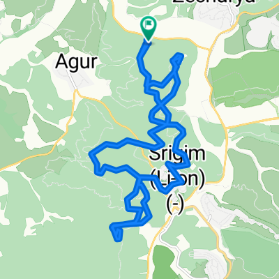
סינגל עדולם
A cycling route starting in Bet Shemesh, Jerusalem District, Israel.
Overview
About this route
קושי: בינוני
מקוצר: <span style="color: rgb(56, 58, 55); font-family: Arial; text-align: -webkit-right;">הסינגל הקלאסי של אזור השפלה. סינגל ארוך המאחד קטעי רכיבה מהירים וזורמים עם קטעים אתגריים וגדושי אלמנטים טכנים.</span> <span style="color: rgb(56, 58, 55); font-family: Arial; text-align: -webkit-right;">מאורך: </span><span style="color: rgb(56, 58, 55); font-family: Arial; text-align: -webkit-right;">המסלול מתחיל בעלייה מתונה אך מוצלת, בדרך עפר המסומנת בירוק. במפגש עם דרך עפר המסומנת בשחור פונים ימינה ולאחר כ -1.3 ק"מ פונים אל שביל המסומן בירוק (סינגל עדולם) היורד מהר שוכה. בחרבת ריבוע מומלץ לעצור למנוחה ותצפית, כאן גם חותך את המסלול שביל המסומן בשחור (סינגל קנים). השביל יורד מהחרבה דרומה ונגמר במפגש עם דרך סלולה המסומנת כחול. ממשיכים דרומה עם הדרך "הכחולה" ולאחר כ- 500 מ' חוברים חזרה אל השביל המסומן בירוק. מעכשיו עוקבים אחרי הסימון בקנאות עד לנקודת הסיום.</span> הערות: למי שרוצה מסלול מעגלי: בחרבת ריבוא, לעבור אל סינגל קנים ולרכב איתו מזרחה. בסמוך לחרבת עתרי חוזרים לסינגל עדולם, איתו רוכבים צפונה ובחרבת ריבוא שוב עוברים לסינגל קנים אך הפעם רוכבים מערבה. במפגש עם דרך עפר המסומנת בכחול פונים ימינה חזרה לנקודת ההתחלה (סה"כ<span dir="LTR">29 </span> ק"מ). (לקוח מאתר shevilnet.net)- -:--
- Duration
- 31.5 km
- Distance
- 575 m
- Ascent
- 575 m
- Descent
- ---
- Avg. speed
- ---
- Max. altitude
Route quality
Waytypes & surfaces along the route
Waytypes
Path
14.2 km
(45 %)
Track
12.3 km
(39 %)
Surfaces
Paved
1.6 km
(5 %)
Unpaved
0.6 km
(2 %)
Asphalt
1.6 km
(5 %)
Unpaved (undefined)
0.3 km
(1 %)
Continue with Bikemap
Use, edit, or download this cycling route
You would like to ride סינגל עדולם or customize it for your own trip? Here is what you can do with this Bikemap route:
Free features
- Save this route as favorite or in collections
- Copy & plan your own version of this route
- Sync your route with Garmin or Wahoo
Premium features
Free trial for 3 days, or one-time payment. More about Bikemap Premium.
- Navigate this route on iOS & Android
- Export a GPX / KML file of this route
- Create your custom printout (try it for free)
- Download this route for offline navigation
Discover more Premium features.
Get Bikemap PremiumFrom our community
Other popular routes starting in Bet Shemesh
 Leg working
- Distance
- 12.1 km
- Ascent
- 226 m
- Descent
- 238 m
- Location
- Bet Shemesh, Jerusalem District, Israel
 פארק בריטניה, מצפה משואה
- Distance
- 19.9 km
- Ascent
- 429 m
- Descent
- 431 m
- Location
- Bet Shemesh, Jerusalem District, Israel
 Easy ride
- Distance
- 7.3 km
- Ascent
- 102 m
- Descent
- 156 m
- Location
- Bet Shemesh, Jerusalem District, Israel
 סיבוב יער
- Distance
- 7.8 km
- Ascent
- 188 m
- Descent
- 187 m
- Location
- Bet Shemesh, Jerusalem District, Israel
 מנזרים ופארק עדולם
- Distance
- 63.8 km
- Ascent
- 778 m
- Descent
- 782 m
- Location
- Bet Shemesh, Jerusalem District, Israel
 דרך הפסלים,חקר שבילים בהר תנופה
- Distance
- 16.6 km
- Ascent
- 285 m
- Descent
- 282 m
- Location
- Bet Shemesh, Jerusalem District, Israel
 zafririm - Mizpe Ramon - Eilat
- Distance
- 297 km
- Ascent
- 1,179 m
- Descent
- 1,477 m
- Location
- Bet Shemesh, Jerusalem District, Israel
 Relaxed route
- Distance
- 10.8 km
- Ascent
- 178 m
- Descent
- 213 m
- Location
- Bet Shemesh, Jerusalem District, Israel
Open it in the app