

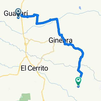
travesia huakar bike y hormigas team
A cycling route starting in Guacarí, Valle del Cauca Department, Colombia.
Overview
About this route
crossing of Clubs Huakar Bike and Hormigas Team
- -:--
- Duration
- 40.9 km
- Distance
- 1,024 m
- Ascent
- 1,020 m
- Descent
- ---
- Avg. speed
- ---
- Max. altitude
Continue with Bikemap
Use, edit, or download this cycling route
You would like to ride travesia huakar bike y hormigas team or customize it for your own trip? Here is what you can do with this Bikemap route:
Free features
- Save this route as favorite or in collections
- Copy & plan your own version of this route
- Sync your route with Garmin or Wahoo
Premium features
Free trial for 3 days, or one-time payment. More about Bikemap Premium.
- Navigate this route on iOS & Android
- Export a GPX / KML file of this route
- Create your custom printout (try it for free)
- Download this route for offline navigation
Discover more Premium features.
Get Bikemap PremiumFrom our community
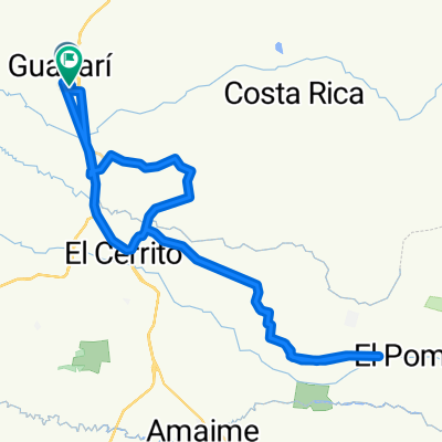
Other popular routes starting in Guacarí
 HORMIGAS
- Distance
- 43.8 km
- Ascent
- 971 m
- Descent
- 968 m
- Location
- Guacarí, Valle del Cauca Department, Colombia
 travesia huakar bike y hormigas team
- Distance
- 40.9 km
- Ascent
- 1,024 m
- Descent
- 1,020 m
- Location
- Guacarí, Valle del Cauca Department, Colombia
 Route from Calle 5 2-1–2-99, El Cerrito
- Distance
- 16.8 km
- Ascent
- 50 m
- Descent
- 64 m
- Location
- Guacarí, Valle del Cauca Department, Colombia
 De Calle sur 2C - a Calle 3ª # 1-99
- Distance
- 24.4 km
- Ascent
- 191 m
- Descent
- 93 m
- Location
- Guacarí, Valle del Cauca Department, Colombia
 Supersonic route in El Cerrito
- Distance
- 28.9 km
- Ascent
- 971 m
- Descent
- 868 m
- Location
- Guacarí, Valle del Cauca Department, Colombia
 ruta dom 2 fe 2014
- Distance
- 46.3 km
- Ascent
- 1,318 m
- Descent
- 1,314 m
- Location
- Guacarí, Valle del Cauca Department, Colombia
 el paraíso guacari
- Distance
- 57.1 km
- Ascent
- 655 m
- Descent
- 698 m
- Location
- Guacarí, Valle del Cauca Department, Colombia
 daniel
- Distance
- 18.3 km
- Ascent
- 228 m
- Descent
- 15 m
- Location
- Guacarí, Valle del Cauca Department, Colombia
Open it in the app