
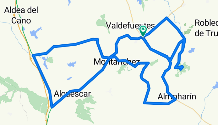
MONTANCHEZ - CANTOS BLANCOS
A cycling route starting in Torre de Santa María, Extremadura, Spain.
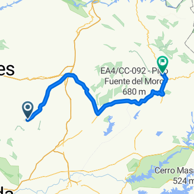
Overview
About this route
SUBIDA A MONTANCHEZ Y RADAR METEREOLOGICO ZARZA (CANTOS BLANCOS)
- -:--
- Duration
- 109.4 km
- Distance
- 1,519 m
- Ascent
- 1,349 m
- Descent
- ---
- Avg. speed
- 810 m
- Max. altitude

Route quality
Waytypes & surfaces along the route
Waytypes
Busy road
44.3 km
(40 %)
Road
32.5 km
(30 %)
Surfaces
Paved
34.3 km
(31 %)
Unpaved
5.1 km
(5 %)
Paved (undefined)
18.5 km
(17 %)
Asphalt
15.9 km
(14 %)
Route highlights
Points of interest along the route
Point of interest after 13 km
GIRO DCHA: tomar ctra Arroyomolinos en entrada ALMOHARIN
Point of interest after 18.5 km
CRUCE DCHA EN MEDIO CTRA SIN INDICACION. Inicio Puerto LA QUEBRADA
Point of interest after 32.3 km
EN ROTONDA TOMAR DIRECCION ALCUESCAR
Point of interest after 45.4 km
CRUCE HERRERIAS tomar N630 direccion Cáceres
Point of interest after 53.6 km
GIRAR DIRECCION CASAS DON ANTONIO Atravesar pueblo y seguir Ctra Local direccon Albala
Point of interest after 64.8 km
Direccion Montanchez
Point of interest after 68.3 km
EN ROTONDA, tomar a la izda para bajar a Torre Santa Maria (Direccion Trujillo)
Point of interest after 75.8 km
SEGUIR EN ROTONDA DIRECCION TRUJILLO
Accommodation after 76.4 km
INICIO Direccion Miajadas Desde Cruce de las Torres
Point of interest after 81.9 km
TOMAR CRUCE ZARZA
Point of interest after 86.5 km
CRUZAR PUEBLO. En Cruz Seguir Ctra entre cercas direccion Radar Metereologico
Point of interest after 87.4 km
AL LLEGAR A CRUCE DE INCIO SUBIDA. TOMAR A LA IZDA CTRA SIN ATRAVESAR EL PUEBLO, DEJANDOLO A LA DCHA
Photo after 93 km
LLEGAR HASTA VALLA ENTRADA Y VOLVERS POR EL MISMO CAMINO
Point of interest after 102.9 km
GIRO A LA DCHA PARA VOLVER A INCIO
Continue with Bikemap
Use, edit, or download this cycling route
You would like to ride MONTANCHEZ - CANTOS BLANCOS or customize it for your own trip? Here is what you can do with this Bikemap route:
Free features
- Save this route as favorite or in collections
- Copy & plan your own version of this route
- Split it into stages to create a multi-day tour
- Sync your route with Garmin or Wahoo
Premium features
Free trial for 3 days, or one-time payment. More about Bikemap Premium.
- Navigate this route on iOS & Android
- Export a GPX / KML file of this route
- Create your custom printout (try it for free)
- Download this route for offline navigation
Discover more Premium features.
Get Bikemap PremiumFrom our community
Other popular routes starting in Torre de Santa María
 ruta 04
- Distance
- 78.9 km
- Ascent
- 427 m
- Descent
- 516 m
- Location
- Torre de Santa María, Extremadura, Spain
 La bola-Quebrada
- Distance
- 61.9 km
- Ascent
- 1,087 m
- Descent
- 1,086 m
- Location
- Torre de Santa María, Extremadura, Spain
 vuelta2
- Distance
- 88 km
- Ascent
- 531 m
- Descent
- 531 m
- Location
- Torre de Santa María, Extremadura, Spain
 Torre-Guadalupe
- Distance
- 111.3 km
- Ascent
- 992 m
- Descent
- 680 m
- Location
- Torre de Santa María, Extremadura, Spain
 MONTANCHEZ - CANTOS BLANCOS
- Distance
- 109.4 km
- Ascent
- 1,519 m
- Descent
- 1,349 m
- Location
- Torre de Santa María, Extremadura, Spain
 vuelta1
- Distance
- 58.1 km
- Ascent
- 465 m
- Descent
- 467 m
- Location
- Torre de Santa María, Extremadura, Spain
 Torre_Caceres-Trujillo-Torre
- Distance
- 120.9 km
- Ascent
- 524 m
- Descent
- 521 m
- Location
- Torre de Santa María, Extremadura, Spain
Open it in the app