

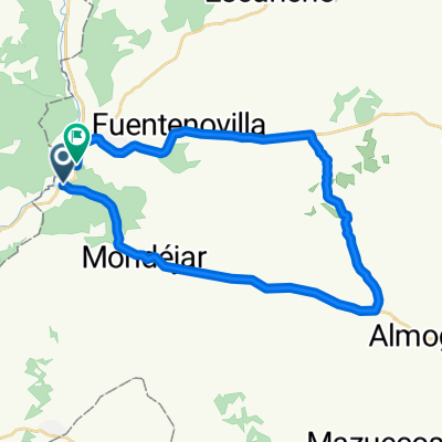
etapa II Ambite-villaescusa de haro
A cycling route starting in Ambite, Madrid, Spain.
Overview
About this route
segunda etapa de travesia madrid/las negras
- -:--
- Duration
- 122.1 km
- Distance
- 982 m
- Ascent
- 779 m
- Descent
- ---
- Avg. speed
- ---
- Max. altitude
Route quality
Waytypes & surfaces along the route
Waytypes
Road
42.7 km
(35 %)
Quiet road
20.8 km
(17 %)
Surfaces
Paved
29.3 km
(24 %)
Unpaved
2.4 km
(2 %)
Asphalt
28.1 km
(23 %)
Gravel
2.4 km
(2 %)
Continue with Bikemap
Use, edit, or download this cycling route
You would like to ride etapa II Ambite-villaescusa de haro or customize it for your own trip? Here is what you can do with this Bikemap route:
Free features
- Save this route as favorite or in collections
- Copy & plan your own version of this route
- Split it into stages to create a multi-day tour
- Sync your route with Garmin or Wahoo
Premium features
Free trial for 3 days, or one-time payment. More about Bikemap Premium.
- Navigate this route on iOS & Android
- Export a GPX / KML file of this route
- Create your custom printout (try it for free)
- Download this route for offline navigation
Discover more Premium features.
Get Bikemap PremiumFrom our community
Other popular routes starting in Ambite
 De Camino del Carrizal, Orusco de Tajuña a Calle Tilo, 6B, Ambite
- Distance
- 3.9 km
- Ascent
- 24 m
- Descent
- 20 m
- Location
- Ambite, Madrid, Spain
 Recovered Route
- Distance
- 15.8 km
- Ascent
- 135 m
- Descent
- 54 m
- Location
- Ambite, Madrid, Spain
 Entrenamiento QH 2/04/2011
- Distance
- 129.7 km
- Ascent
- 1,151 m
- Descent
- 1,160 m
- Location
- Ambite, Madrid, Spain
 hola
hola- Distance
- 30.5 km
- Ascent
- 332 m
- Descent
- 336 m
- Location
- Ambite, Madrid, Spain
 I Clásica de Ambite
- Distance
- 50.2 km
- Ascent
- 579 m
- Descent
- 587 m
- Location
- Ambite, Madrid, Spain
 etapa II Ambite-villaescusa de haro
- Distance
- 122.1 km
- Ascent
- 982 m
- Descent
- 779 m
- Location
- Ambite, Madrid, Spain
 QH sema18 150
- Distance
- 160.1 km
- Ascent
- 847 m
- Descent
- 881 m
- Location
- Ambite, Madrid, Spain
 Clásica de Ambite
- Distance
- 47.4 km
- Ascent
- 530 m
- Descent
- 561 m
- Location
- Ambite, Madrid, Spain
Open it in the app