Pallag 2
- 30.7 km
- 203 m
- 203 m
- Debrecen, Hajdú-Bihar, Hungary
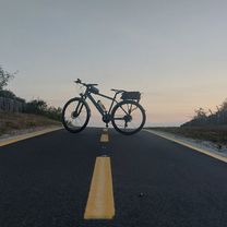
A cycling route starting in Debrecen, Hajdú-Bihar, Hungary.
Overview
Debrecen - Hajdúsámson - Déssytanya - Csiffytanya - Mamutfenyő - Bököny - Téglás - Hajdúhadház - Bocskaikert - Pallag - Debrecen
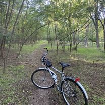
We start our bike tour in front of the Great Church of Debrecen. You can reach the town from Kossuth Square via low-traffic streets and designated bike routes (Péterfia St. - Simonyi St. - Weszprémi St. - Hadházi St. - Zákány St. - Sámsoni St.) to Hajdúsámson. Further from the town, turn left (Petőfi Rd. - Árpád Rd. - Buzogány St.) onto low-traffic dirt roads and continue cycling up to the county border (on dirt roads). After leaving Déssytanya, turn left towards Csiffytanya. Following the road's curve, you will find your destination, the mammoth pine. From here, head towards Bököny, comfortably cycling through the town (József Attila St. - Dózsa György St.) and then continue on low-traffic paved roads to Téglás (Pozsár Gyula St. - Kossuth Lajos St. - Alkotmány St.). From there, head to Hajdúhadház. Riding through the downtown area of Hajdúhadház, head south (Dr. Földi János St. - Béke útja) towards Bocskaikert, using the bike paths running through and connecting the towns. Exiting Bocskaikert, turn onto a dirt road running along the weekend houses of Monostoripallagdűlő, then after a few kilometers, turn left again toward Pallag. From here, head back to Debrecen: you can continue on Pallagi Road if you prefer paved roads (Pallagi Rd. - Simonyi St. - Péterfia St.) or cross a ditch-like formation and then through the forest paths of Nagyerdőtölgyes following the red markings. This route is very popular among locals for running, walking, and cycling, so be very careful and always give priority to runners and walkers when cycling! After about 4 km of straight road, keep right and then return on the bike path to downtown (Benczúr Gyula St. - Pallagi Rd. - Simonyi St. - Péterfia St.).
created this 11 years ago
Route quality
Cycleway
16.7 km
(26 %)
Road
11.6 km
(18 %)
Paved
32.1 km
(50 %)
Unpaved
8.3 km
(13 %)
Asphalt
32.1 km
(50 %)
Loose gravel
3.2 km
(5 %)
Route highlights
Helytörténeti Múzeum
Református templom
Katolikus harangláb
Mamutfenyő
Református templom
Világháborús emlékmű
Földi János Könyvtár; Égerházi Imre Emlékház; Holló László Emlékszoba;
Bocskai lovasszobor
Református kéttornyú templom
Pallag presszó
Balásházy János Szakközépiskola
Tanári villák
Akadémia
Continue with Bikemap
You would like to ride DB-Ex2 | Mamutfenyő or customize it for your own trip? Here is what you can do with this Bikemap route:
Free trial for 3 days, or one-time payment. More about Bikemap Premium.
Discover more Premium features.
Get Bikemap PremiumFrom our community
Open it in the app