
DB-Ex4 | 1000 éves tölgy teljesítménytúra
A cycling route starting in Debrecen, Hajdú-Bihar, Hungary.
Overview
About this route
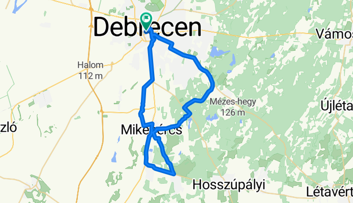
Debrecen - Mikepércs - Sáránd - Hajdúbagos - Hajdúbagosi földi kutya rezervátum - (sárga jelzésen tovább Rókás tavak) - 1000 éves tölgy - Kossuth utcán a sárga jelzésen megyünk tovább - Mikepércs - Vekeri tó felé a zöld jelzésen - Panoráma út - Diószegi út - Vágóhíd utca - Debrecen
- -:--
- Duration
- 43.4 km
- Distance
- 45 m
- Ascent
- 48 m
- Descent
- ---
- Avg. speed
- ---
- Max. altitude

Route quality
Waytypes & surfaces along the route
Waytypes
Track
11.9 km
(27 %)
Busy road
9.6 km
(22 %)
Surfaces
Paved
17.3 km
(40 %)
Unpaved
2.1 km
(5 %)
Asphalt
17.3 km
(40 %)
Gravel
1.1 km
(2 %)
Route highlights
Points of interest along the route
Point of interest after 17.2 km
Derecskei-Kálló
Point of interest after 18 km
Református templom
Point of interest after 18 km
Derecskei-Kálló
Point of interest after 20.1 km
1000 éves (Rákóczi) tölgy
Point of interest after 22.7 km
Református templom
Point of interest after 27.5 km
Vekeri-tó
Point of interest after 33.1 km
Erdőspusztai Bemutatóház és Arborétum
Point of interest after 33.4 km
Fancsikai templomrom
Continue with Bikemap
Use, edit, or download this cycling route
You would like to ride DB-Ex4 | 1000 éves tölgy teljesítménytúra or customize it for your own trip? Here is what you can do with this Bikemap route:
Free features
- Save this route as favorite or in collections
- Copy & plan your own version of this route
- Sync your route with Garmin or Wahoo
Premium features
Free trial for 3 days, or one-time payment. More about Bikemap Premium.
- Navigate this route on iOS & Android
- Export a GPX / KML file of this route
- Create your custom printout (try it for free)
- Download this route for offline navigation
Discover more Premium features.
Get Bikemap PremiumFrom our community
Other popular routes starting in Debrecen
 Pallag All-Star
- Distance
- 15.9 km
- Ascent
- 31 m
- Descent
- 30 m
- Location
- Debrecen, Hajdú-Bihar, Hungary
 Experimental Route #1
- Distance
- 14 km
- Ascent
- 28 m
- Descent
- 26 m
- Location
- Debrecen, Hajdú-Bihar, Hungary
 Évvégi zárótekerés 2018 december
- Distance
- 45.4 km
- Ascent
- 57 m
- Descent
- 50 m
- Location
- Debrecen, Hajdú-Bihar, Hungary
 Debreceni kerülő (Józsától-Józsáig)
- Distance
- 73 km
- Ascent
- 98 m
- Descent
- 98 m
- Location
- Debrecen, Hajdú-Bihar, Hungary
 DB-Ex4 | 1000 éves tölgy teljesítménytúra
- Distance
- 43.4 km
- Ascent
- 45 m
- Descent
- 48 m
- Location
- Debrecen, Hajdú-Bihar, Hungary
 Jósza Lit-run
- Distance
- 17.9 km
- Ascent
- 27 m
- Descent
- 26 m
- Location
- Debrecen, Hajdú-Bihar, Hungary
 Db 40+
- Distance
- 44.7 km
- Ascent
- 1,082 m
- Descent
- 1,086 m
- Location
- Debrecen, Hajdú-Bihar, Hungary
 Nagy-Magyarország határvidék körtúra
- Distance
- 5,159.5 km
- Ascent
- 20,236 m
- Descent
- 20,235 m
- Location
- Debrecen, Hajdú-Bihar, Hungary
Open it in the app