

A la cascada de Chirisacha
A cycling route starting in Otavalo, Imbabura, Ecuador.
Overview
About this route
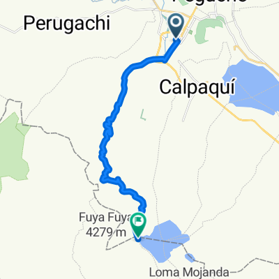
Part of the village of San José de Minas leads to a picturesque waterfall hidden among the northern slopes of Fuya Fuya.
- -:--
- Duration
- 23.1 km
- Distance
- 689 m
- Ascent
- 688 m
- Descent
- ---
- Avg. speed
- ---
- Max. altitude

Continue with Bikemap
Use, edit, or download this cycling route
You would like to ride A la cascada de Chirisacha or customize it for your own trip? Here is what you can do with this Bikemap route:
Free features
- Save this route as favorite or in collections
- Copy & plan your own version of this route
- Sync your route with Garmin or Wahoo
Premium features
Free trial for 3 days, or one-time payment. More about Bikemap Premium.
- Navigate this route on iOS & Android
- Export a GPX / KML file of this route
- Create your custom printout (try it for free)
- Download this route for offline navigation
Discover more Premium features.
Get Bikemap PremiumFrom our community
Other popular routes starting in Otavalo
 Otavalo - Ibarra - Salinas - Tumbabiro - Urcuquí - Imantag - Atuntaqui - Otavalo.
- Distance
- 105 km
- Ascent
- 1,683 m
- Descent
- 1,682 m
- Location
- Otavalo, Imbabura, Ecuador
 Otavalo Laguna de Mojanda
- Distance
- 14.5 km
- Ascent
- 1,146 m
- Descent
- 0 m
- Location
- Otavalo, Imbabura, Ecuador
 Otavalo - Mojada
- Distance
- 14.5 km
- Ascent
- 1,163 m
- Descent
- 20 m
- Location
- Otavalo, Imbabura, Ecuador
 A la cascada de Chirisacha
- Distance
- 23.1 km
- Ascent
- 689 m
- Descent
- 688 m
- Location
- Otavalo, Imbabura, Ecuador
 otavalo quicocha
- Distance
- 37.9 km
- Ascent
- 922 m
- Descent
- 562 m
- Location
- Otavalo, Imbabura, Ecuador
 Otavalo (Lagunas de mojanda, Cochasqui)
- Distance
- 16.4 km
- Ascent
- 1,208 m
- Descent
- 25 m
- Location
- Otavalo, Imbabura, Ecuador
 Vuelta al Imbabura
- Distance
- 48.5 km
- Ascent
- 1,136 m
- Descent
- 1,139 m
- Location
- Otavalo, Imbabura, Ecuador
 Mojanda Cerro Negro
- Distance
- 16.4 km
- Ascent
- 816 m
- Descent
- 817 m
- Location
- Otavalo, Imbabura, Ecuador
Open it in the app